
by Celeste Lipford and Terry Lipford - last updated on 7/23/2025
As of February 19, 2025, Switzerland is home to 13 UNESCO World Heritage Sites, showcasing its rich cultural, historical, and natural heritage. Additionally, there is 1 site currently on Switzerland's tentative list, under consideration for future inscription by UNESCO.
Switzerland's UNESCO World Heritage Sites encompass a remarkable diversity of cultural, historical, and natural wonders, reflecting the nation's diverse heritage, architectural achievements, and breathtaking landscapes. These sites range from medieval towns and Viking-era settlements to stunning fjords and pristine natural reserves, each telling a unique story of Switzerland past and its deep-rooted connection to both nature and human innovation.
The majority of the following information came from the "List of World Heritage Sites in Switzerland". Some portions of the text narrative was created with the assistance of OpenAI. (2025). ChatGPT [Large language model].
Whenever applicable, we have provided links to our destination pages whenever a UNESCO Site is associated with that destination.
Note: We have long planned another trip to Switzerland to explore more of its UNESCO World Heritage Sites — especially the cities and alpine regions we missed during our first visit. Unfortunately, those plans were delayed due to COVID-related travel restrictions. We still hope to return and update this page with firsthand experiences in the near future.
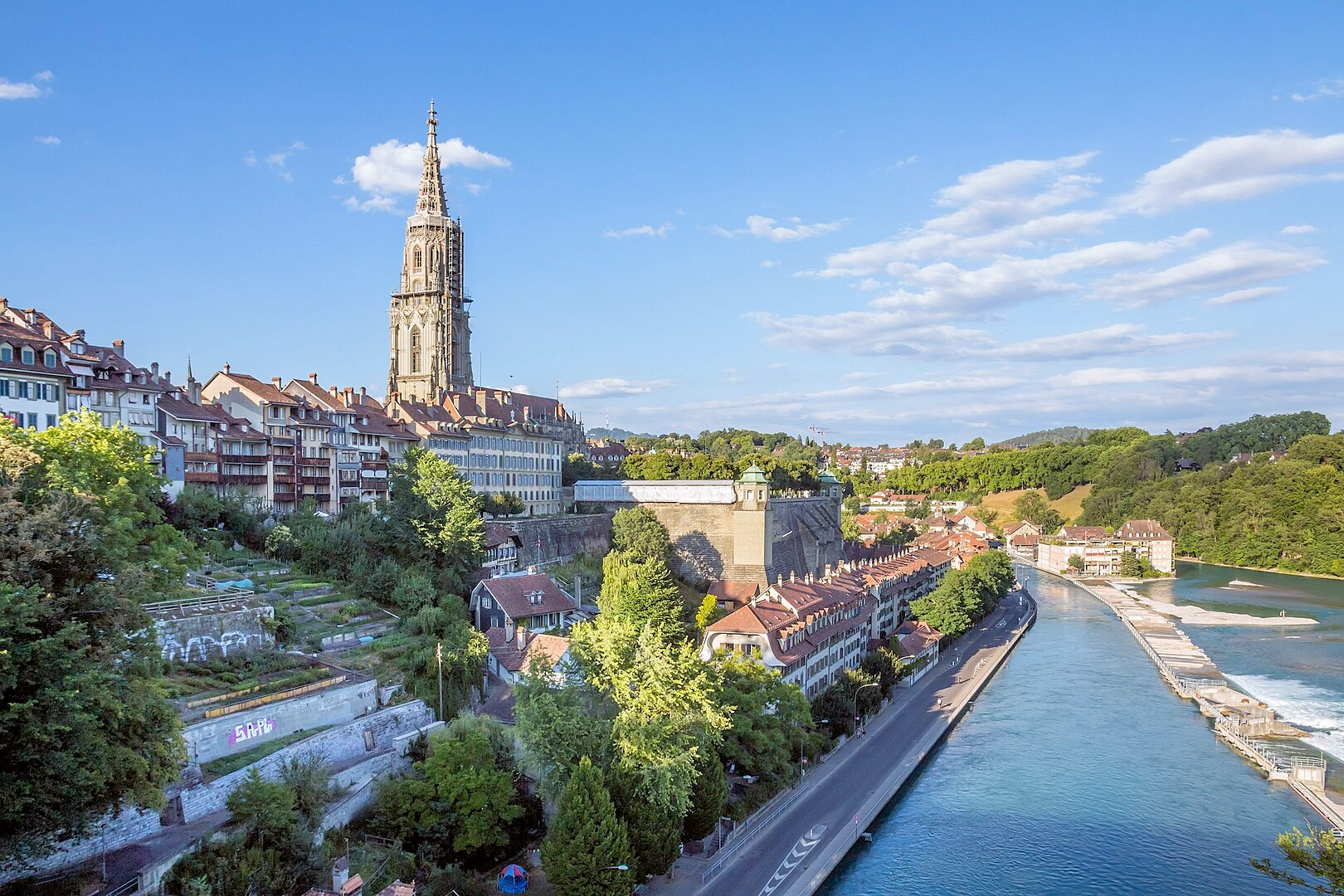
The medieval heart of Switzerland’s capital city, the Old City of Bern is a remarkably well-preserved example of urban planning dating back to the 12th century. Perched on a sandstone ridge and wrapped by the Aare River on three sides, the historic core is a unique blend of arcaded walkways, cobblestone lanes, and centuries-old architecture that reflects Bern’s growth over the ages. Despite several fires and modern developments, the city’s layout has remained largely unchanged, offering visitors a chance to step back into the past while still enjoying a vibrant modern atmosphere.
From the iconic Zytglogge clock tower to the stately Federal Palace and charming fountains topped with colorful figures, the Old City reveals Bern’s historical and political significance. The area’s sandstone buildings, many dating back to the 15th and 16th centuries, now house boutiques, cafes, and galleries beneath the arcades, making it one of Europe’s most walkable and atmospheric old towns. Its seamless fusion of heritage and daily life earned it a place on the UNESCO World Heritage list in 1983.
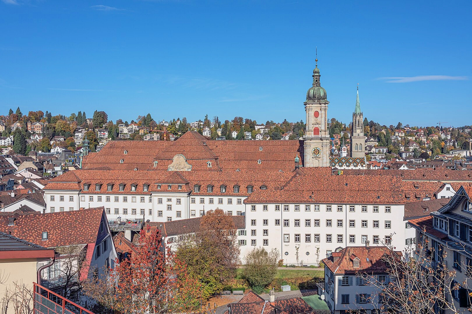
The Convent of St. Gall, located in the heart of the city of St. Gallen, is one of the most important cultural and architectural landmarks in Switzerland. Originally founded in the 8th century, the abbey became one of the leading centers of learning in Europe during the Middle Ages, renowned for its scriptorium and vast library.
At the heart of the convent lies the Abbey Library of Saint Gall, a Baroque masterpiece that holds over 170,000 books and manuscripts, some dating back to the 8th century. Stepping into the library feels like walking into a sanctuary of knowledge — elaborately carved woodwork, stunning ceiling frescoes, and rare volumes displayed in pristine cases all contribute to its aura.
The cathedral and the remaining monastic buildings reflect a harmonious blend of Carolingian and Baroque architecture. Although the monastic functions ceased in the 19th century, the site has been carefully preserved and continues to draw historians, architecture enthusiasts, and curious travelers alike.
A visit to the Convent of St. Gall isn’t just about admiring old books and fine architecture — it’s a chance to witness the legacy of a medieval powerhouse of intellect and culture that helped shape European scholarship.
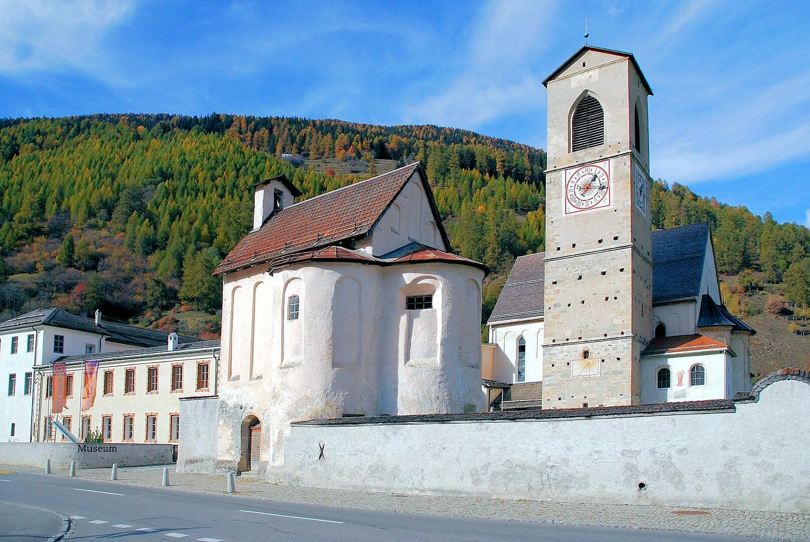
Tucked away in a remote valley of the canton of Graubünden, near the Italian border, the Benedictine Convent of Saint John at Müstair offers a striking glimpse into early medieval monastic life in the Alps. Founded around 775 by order of Charlemagne, the convent is one of the best-preserved examples of Carolingian architecture and religious art in Europe.
What makes this UNESCO World Heritage Site so extraordinary is the richness of its wall paintings. The convent church holds the largest and most complete cycle of early medieval frescoes north of the Alps, dating from the 9th century — with later additions spanning several centuries. These frescoes vividly depict biblical scenes and are considered invaluable for the study of medieval Christian art.
Still a functioning convent, the site offers visitors the chance to tour a small but compelling museum that explains the history of the monastic community and the architectural evolution of the complex. The setting itself, surrounded by mountains and alpine pastures, adds to the sense of timeless serenity. Visiting Müstair feels like stepping into a living chapter of European history — peaceful, contemplative, and deeply rooted in the spiritual and cultural life of Switzerland.
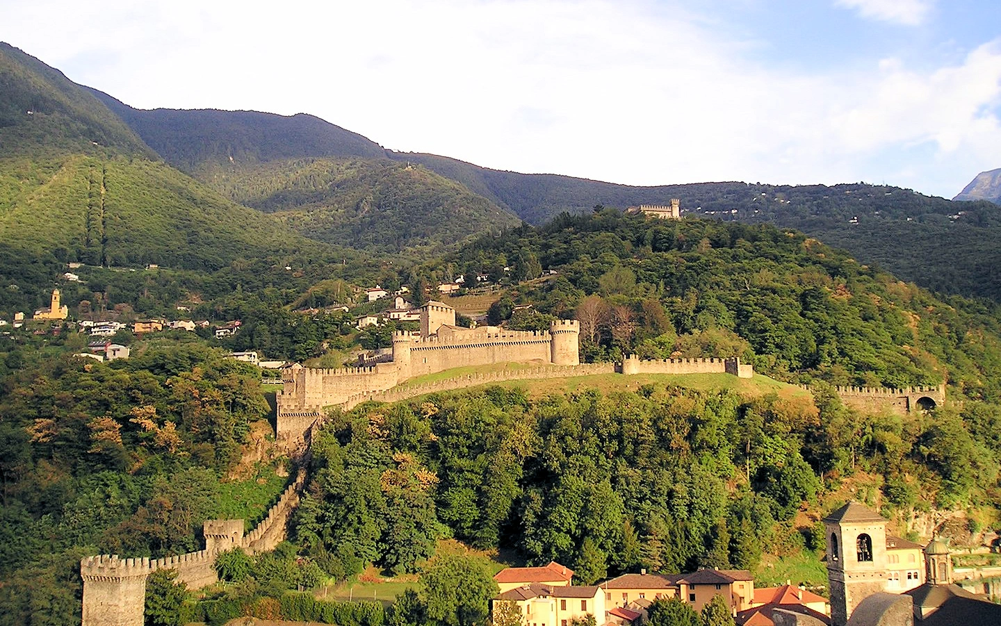
Rising dramatically above the Ticino Valley, the trio of medieval castles in Bellinzona — Castelgrande, Montebello, and Sasso Corbaro — form one of Switzerland’s most iconic fortified complexes and a UNESCO World Heritage Site. Strategically perched at the southern gateway to the Alps, these castles once served as a critical defensive barrier controlling trade and military routes between northern and southern Europe.
Each fortress has its own character:
Today, the castles are open to the public and interconnected by walking trails. Inside, you'll find museums, archaeological exhibits, and immersive displays of the region’s military history. The town of Bellinzona itself — with its Italian-influenced architecture, weekly markets, and mountain backdrop — makes for a charming stop on any itinerary through southern Switzerland.
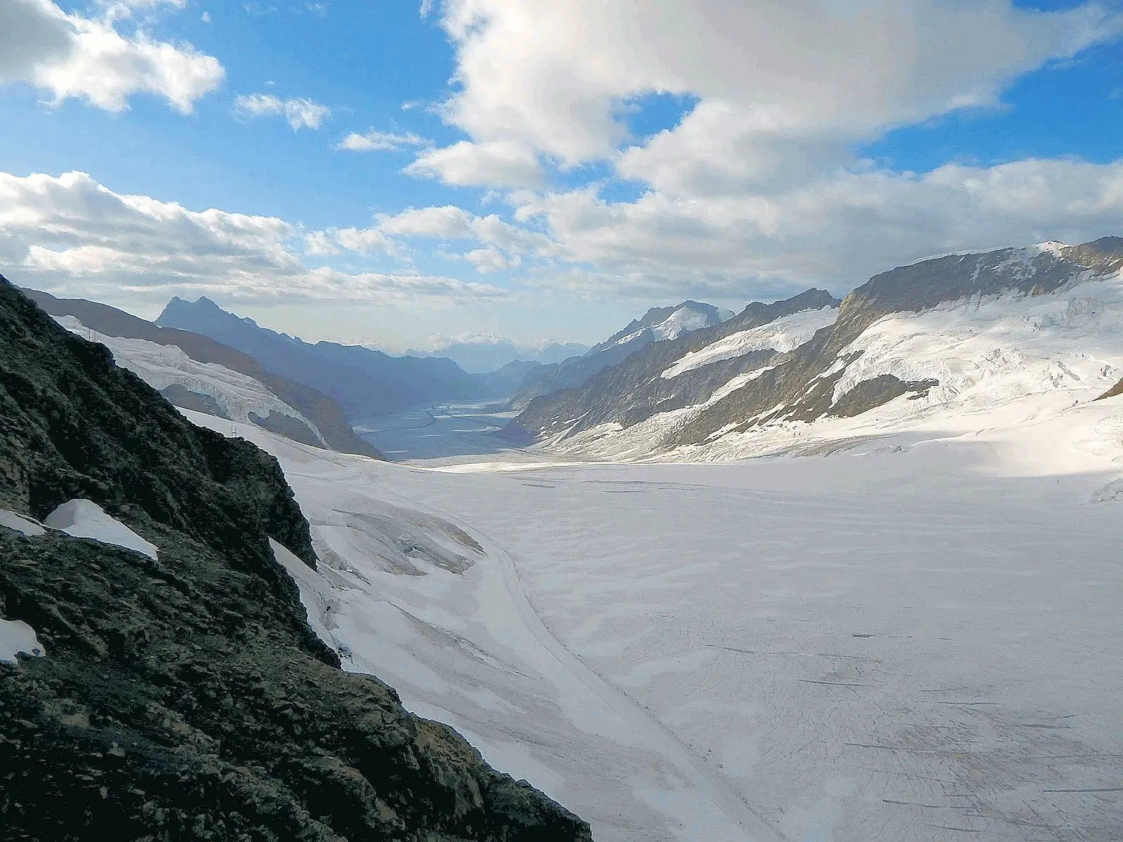
The Jungfrau-Aletsch region is the glacial heart of the Alps — a dramatic landscape of rugged peaks, sweeping icefields, and pristine alpine valleys. Recognized as Switzerland’s first UNESCO World Heritage Site in 2001, this protected area spans over 800 square kilometers and includes the iconic Jungfrau, Eiger, and Mönch peaks, along with the immense Aletsch Glacier — the longest glacier in the Alps at over 20 kilometers.
This high-altitude wonderland isn't just about scenery. It's also a vital climate research site and a living example of how glaciers have shaped Europe’s geography over millennia. Towering cliffs, deep crevasses, and rare alpine flora make the region both geologically significant and breathtakingly beautiful.
Visitors can explore the area from multiple access points, but one of the most popular gateways is Grindelwald, a charming alpine village nestled below the Eiger's north face. From Grindelwald, scenic trains and cable cars lead up to alpine viewpoints like Jungfraujoch — often called the “Top of Europe.” Whether hiking, skiing, or simply admiring the vast expanse of glacier and rock, the Jungfrau-Aletsch region leaves a lasting impression.
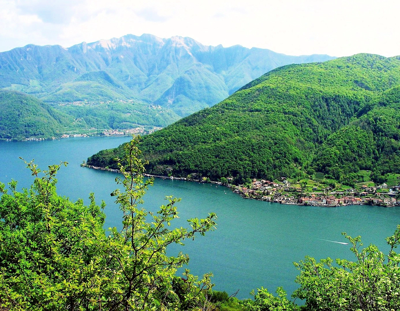
Monte San Giorgio may look like just another scenic mountain along the shores of Lake Lugano, but beneath its slopes lies one of the world's most significant fossil troves. This pyramid-shaped peak straddling the Swiss-Italian border was added to the UNESCO list in 2003 for its exceptionally well-preserved marine fossils from the Middle Triassic period — around 240 million years ago.
At that time, the region was a tropical lagoon teeming with prehistoric life. Today, paleontologists continue to uncover skeletons of ancient reptiles, fish, and crustaceans, providing a detailed snapshot of life after the Permian mass extinction. Over 20,000 fossil specimens have been extracted from Monte San Giorgio’s limestone layers, making it a scientific treasure.
Visitors interested in the site’s paleontological significance can explore the Fossil Museum of Monte San Giorgio in nearby Meride, which showcases many of the site’s most important discoveries. Hiking trails around the mountain also offer panoramic views of Lake Lugano and the surrounding Ticino countryside — combining science, nature, and beauty in one experience.
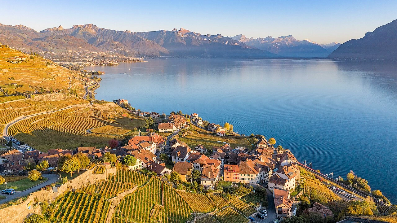
Stretching for about 30 kilometers along the northern shores of Lake Geneva, the Lavaux Vineyard Terraces are among the most iconic and picturesque wine regions in Switzerland. Recognized by UNESCO in 2007, this sweeping landscape of neatly arranged terraces has been cultivated for over 800 years, originally developed by Benedictine and Cistercian monks in the 11th century.
What makes Lavaux exceptional is how the terrain has been shaped by human hands in harmony with nature. Stone walls support steep vineyard slopes that benefit from a unique “three-sun” effect — direct sunlight, reflection off Lake Geneva, and heat retained by the stone walls — ideal conditions for growing Chasselas grapes and producing crisp, mineral-rich white wines.
Lavaux isn’t just a feast for the taste buds — it’s also a hiker’s and cyclist’s paradise. The Lavaux Vineyard Trail meanders through charming wine villages like Saint-Saphorin, Dézaley, and Epesses, offering sweeping views of the lake and Alps beyond. Along the way, you’ll find welcoming cellars and tasting rooms that blend rustic authenticity with world-class quality.
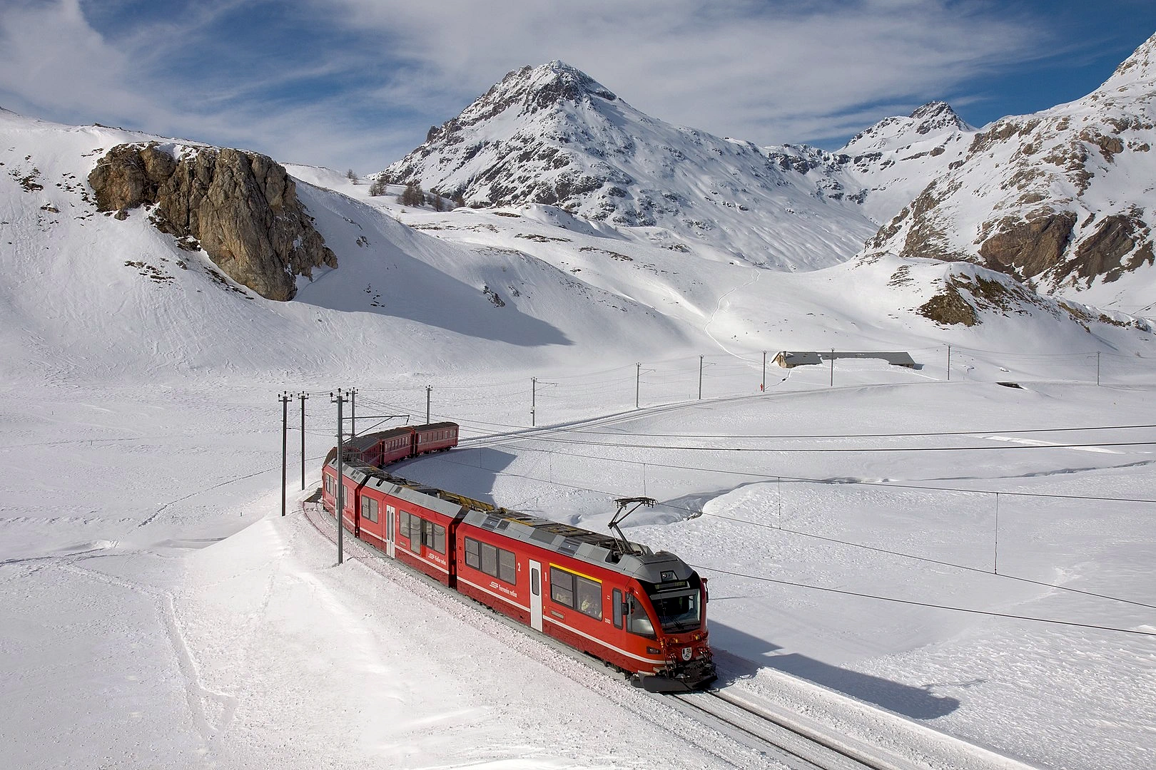
The Rhaetian Railway, particularly its Albula and Bernina lines, offers one of the most scenic rail journeys in the world — and it’s more than just a beautiful ride. Recognized by UNESCO in 2008, this rail network is celebrated for its engineering ingenuity and harmony with the rugged alpine landscape. Connecting the Swiss towns of Thusis and St. Moritz with Tirano in Italy, the route crosses 122 kilometers of dramatic mountain terrain, climbing from palm-fringed valleys to glacial peaks.
Highlights of the journey include the Landwasser Viaduct, a jaw-dropping curved bridge that appears to spring directly from the mountainside, and the Bernina Pass, where the train reaches over 2,200 meters above sea level. Along the way, passengers cross 55 tunnels and 196 bridges, all seamlessly integrated into the surrounding environment.
Traveling on the Bernina Express — the flagship panoramic train on this route — is like riding through a living postcard. Vast glaciers, turquoise lakes, and charming alpine villages glide past the windows, with every turn offering a new cinematic view. It’s both a technical marvel and an unforgettable way to experience the Swiss Alps.
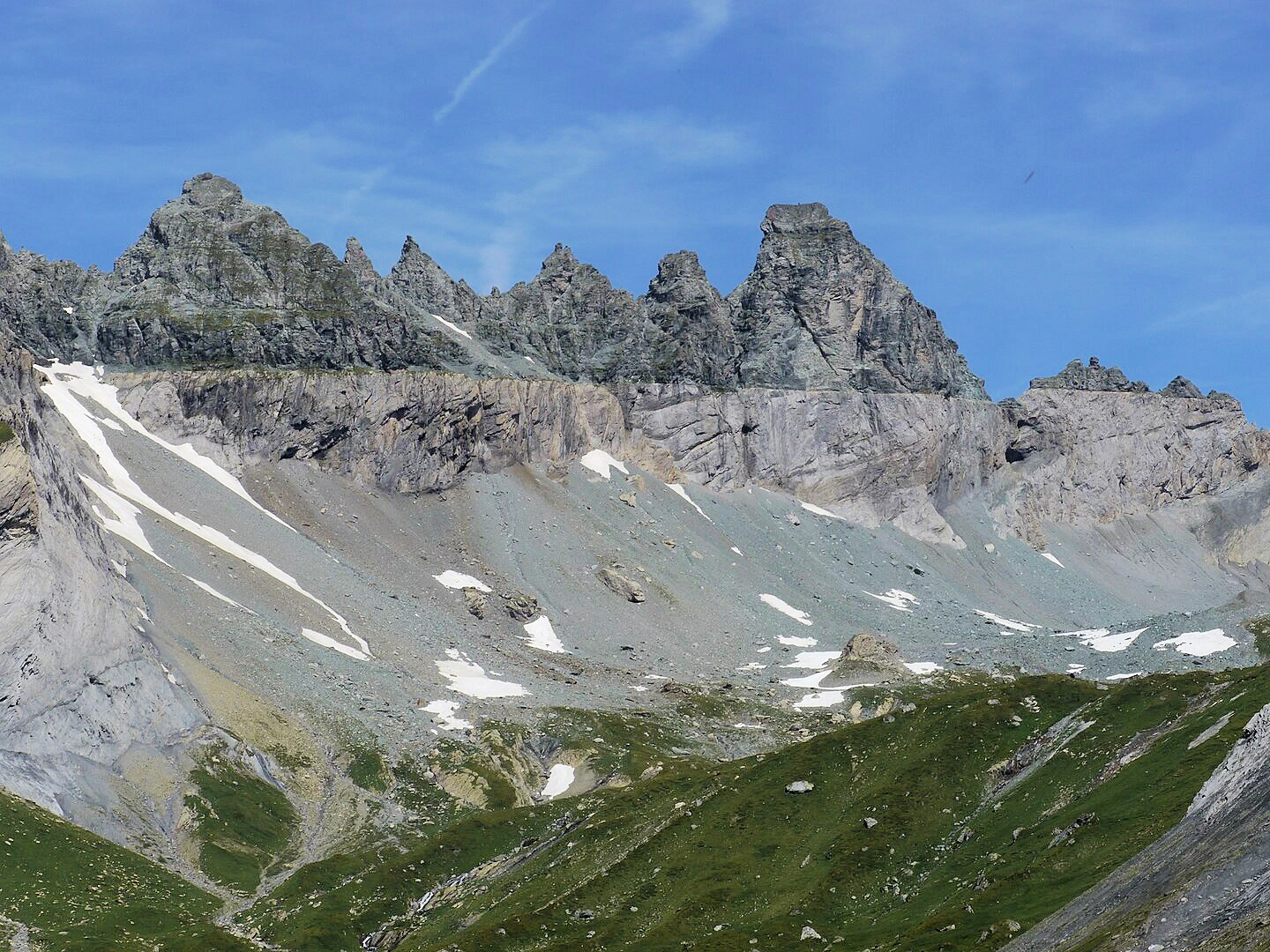
At first glance, the mountains of eastern Switzerland are simply stunning — but look a little deeper, and they tell a geological story nearly impossible to ignore. The Swiss Tectonic Arena Sardona, added to the UNESCO World Heritage list in 2008, is a rare place where the very bones of the Earth are exposed in extraordinary clarity. This region offers some of the best visible evidence of mountain formation through plate tectonics — specifically, how older rock layers were thrust over younger ones during the formation of the Alps.
The most iconic feature is the Glarus Thrust, a nearly horizontal line that stretches for miles across the mountainsides, where ancient rocks (around 250–300 million years old) have been pushed up and over much younger layers (only 35–50 million years old). This geological oddity, visible with the naked eye, has been studied since the 18th century and remains a landmark site for geologists worldwide.
While the science is impressive, the experience is also spectacular. Visitors can hike through dramatic alpine scenery, explore rugged valleys, and see firsthand how the Earth literally folds and shifts. It’s an ideal destination for nature lovers and science-minded travelers alike — a place where mountains are not just scenery, but a record of Earth's dynamic history.
Nestled in the Jura Mountains of western Switzerland, the twin towns of La Chaux-de-Fonds and Le Locle are far more than charming alpine settlements — they are the birthplace of the Swiss watchmaking industry. Recognized by UNESCO in 2009, this World Heritage site isn’t just about the craft of precision timekeeping; it’s about how two entire towns were intentionally shaped by the demands of watch production.
After devastating fires in the late 18th and early 19th centuries, both towns were rebuilt with a remarkably modern approach: wide streets, grid-like layouts, and mixed-use buildings that integrated living quarters and watchmaking workshops under one roof. This innovative urban planning — designed to maximize light, workflow, and efficiency for artisans — remains evident today.
La Chaux-de-Fonds is also the birthplace of the famed architect Le Corbusier, whose early surroundings reflected the blend of functionality and aesthetic precision that would shape his career. Museums, historic factories, and even modern ateliers allow visitors to trace the evolution of watchmaking from hand-crafted pocket watches to today’s luxury brands.
For lovers of craftsmanship, industrial design, or Swiss heritage, a visit to these towns offers an immersive look at a uniquely time-bound legacy.
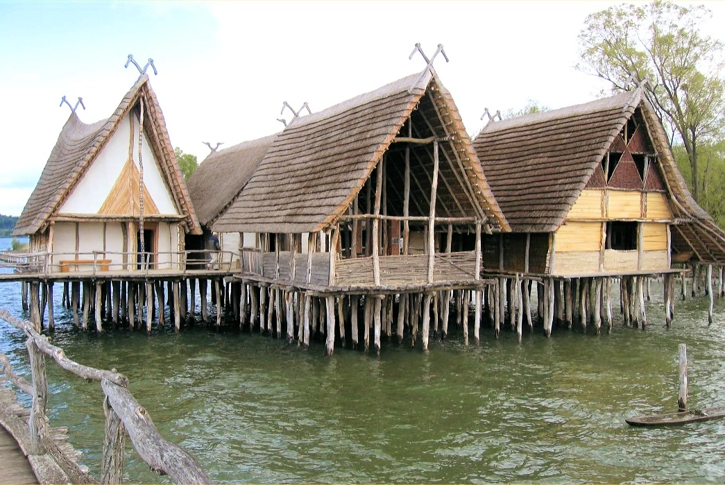
Long before castles, cathedrals, or chalets dotted the Swiss landscape, prehistoric communities were already thriving across the region’s lakeshores. The Prehistoric Pile Dwellings — wooden stilt houses built between 5000 and 500 BCE — represent some of the earliest known settlements in Europe. Today, select archaeological remains from over 100 sites across six Alpine countries (including 11 in Switzerland) are protected under this UNESCO designation.
These ancient lake dwellings were ingeniously constructed over water or wetlands to protect against flooding and pests, and their preservation beneath lakebeds offers a remarkable snapshot of Neolithic and Bronze Age life. Tools, ceramics, remnants of food, and even textiles have been uncovered — giving scientists extraordinary insight into early agriculture, social structures, and environmental adaptation.
Swiss locations like Lake Zurich, Lake Neuchâtel, and Lake Geneva house some of the best-preserved examples. While the original wooden structures are long gone above the waterline, submerged pilings and interpretive centers (such as the Laténium Museum in Neuchâtel) allow visitors to explore this hidden layer of European history.
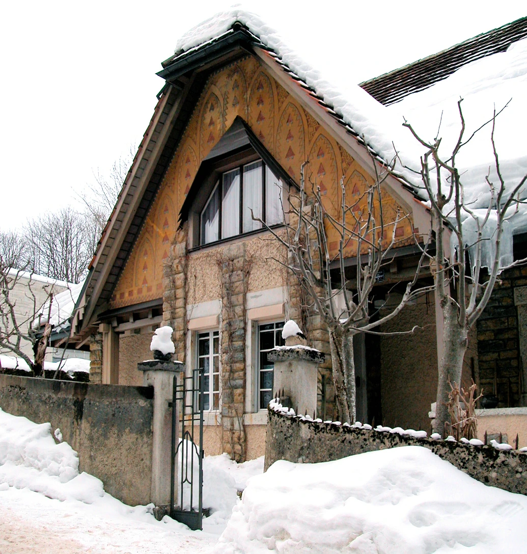
Among the pioneers of 20th-century architecture, Le Corbusier left a global imprint that redefined how we live, build, and think about space. This UNESCO World Heritage Site encompasses 17 of his works across seven countries, and in Switzerland, it’s represented by the Maison Blanche (White House) in La Chaux-de-Fonds.
Completed in 1912, the Maison Blanche was Le Corbusier’s first independent architectural commission — and perhaps one of his most personal, as it was designed for his parents. Though early in his career, the house already shows his emerging principles of functionalism, clarity of form, and the rejection of ornamentation that would later define the modernist movement.
Unlike the concrete and glass structures for which he later became famous, the Maison Blanche blends regional building traditions with radical new ideas about domestic space. Walking through it today offers a rare look at the formative thinking of a man who would go on to influence architecture on every continent.
Visitors to La Chaux-de-Fonds can explore both the house and the city’s strong horological and architectural heritage — making it a meaningful stop for design lovers and modern architecture enthusiasts.
An error (2) occurred on line 1025 and in the file: /opt/bitnami/apache/htdocs/justTravelingThru/amazon_ads_functions.php.
getimagesize(home_page_images/webp_format/thumbnails/Beușnița_valley.webp): Failed to open stream: No such file or directory