
by Celeste Lipford and Terry Lipford - last updated on 9/16/2025
We first visited Munich in 1996, a city that holds a special place in my heart. I had the privilege of working here with Siemens during the 1980s, which gave me the opportunity to travel here frequently. However, we hadn’t been back in quite some time, so when the chance arose to return, we jumped at it. We were eager to introduce Germany to our teenage son and reconnect with some dear friends who live in the city, making a week-long stay in Munich the perfect choice.
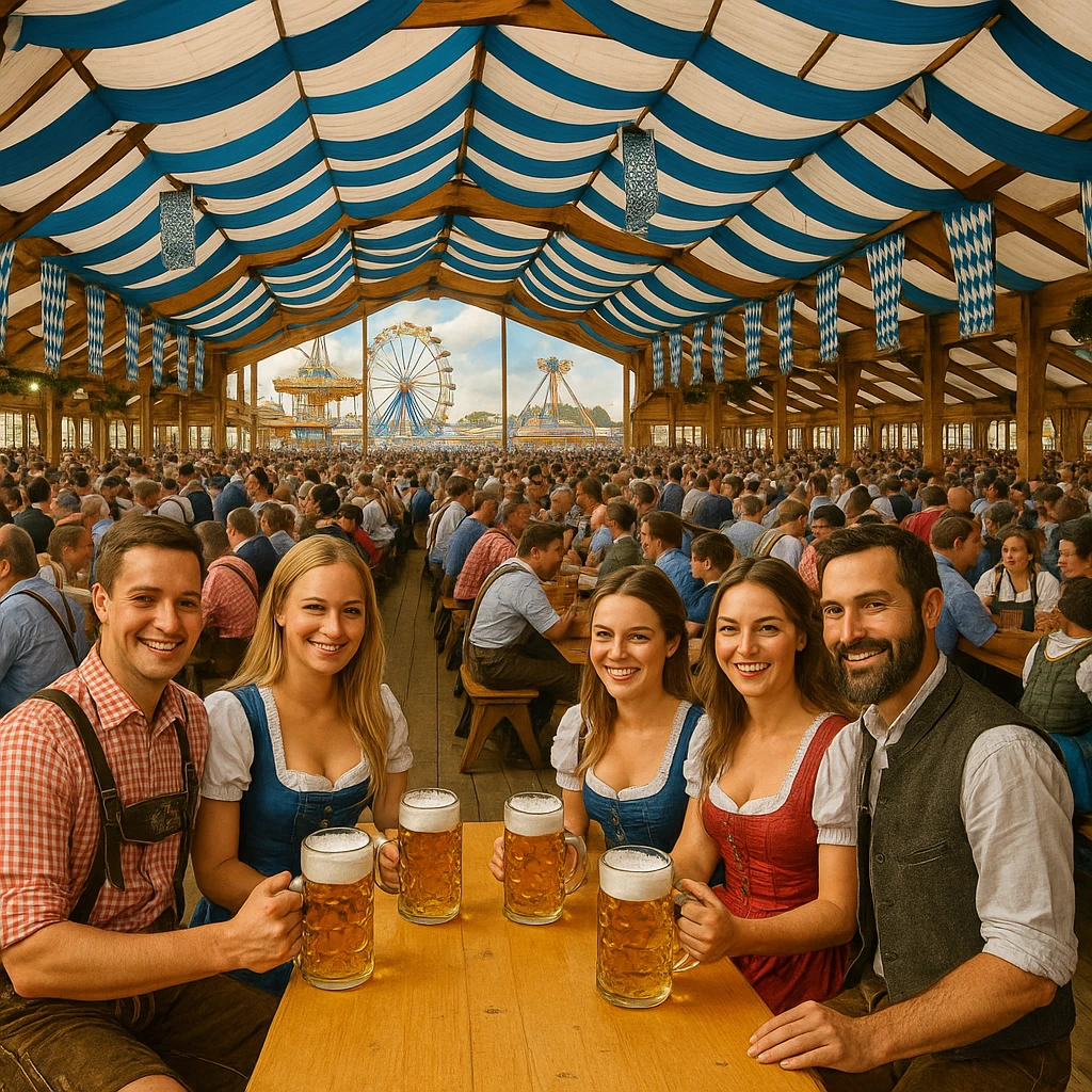
Munich, the third-largest city in Germany, is a dynamic blend of modernity and tradition, offering a rich tapestry of history, culture, and natural beauty. The city is renowned for its architectural gems, historical sites, and world-class museums, but also for its lush parks and iconic outdoor beer gardens, where you can relax with a cold beer and a warm pretzel while soaking in the vibrant atmosphere. The city is particularly famous for Oktoberfest, held every year in September, an extraordinary festival that brings together locals and visitors in an outdoor amusement park-style setting filled with rides, music, traditional Bavarian food, and, of course, beer.
One of the most striking features of Munich is the Isar River, which gracefully flows through the city. Along its banks, you’ll find several beautiful parks offering stunning views of the river, with the English Garden being my personal favorite. As one of the largest urban parks in the world, the English Garden offers sprawling green spaces, picturesque walking paths, and large beer gardens, making it an ideal spot for a leisurely afternoon on a warm summer day.
Munich is also a fantastic city for families, and it’s easy to see why. The concept of family is deeply ingrained in German culture, and children are often included in all kinds of activities. In fact, many of Munich\'s famous beer gardens feature playgrounds where kids can have fun while their parents enjoy food and drinks. There’s no shortage of activities that cater to both fun and education, making Munich a great destination for all ages. You can visit the fairytale-like Neuschwanstein Castle, built by King Ludwig II, or explore the rich history of Ludwig’s castles, which are scattered across the Bavarian countryside. For those interested in history, a visit to one of the concentration camp memorials around Munich is a somber but important experience that serves as a reminder of the atrocities that occurred during World War II, ensuring that future generations never forget.
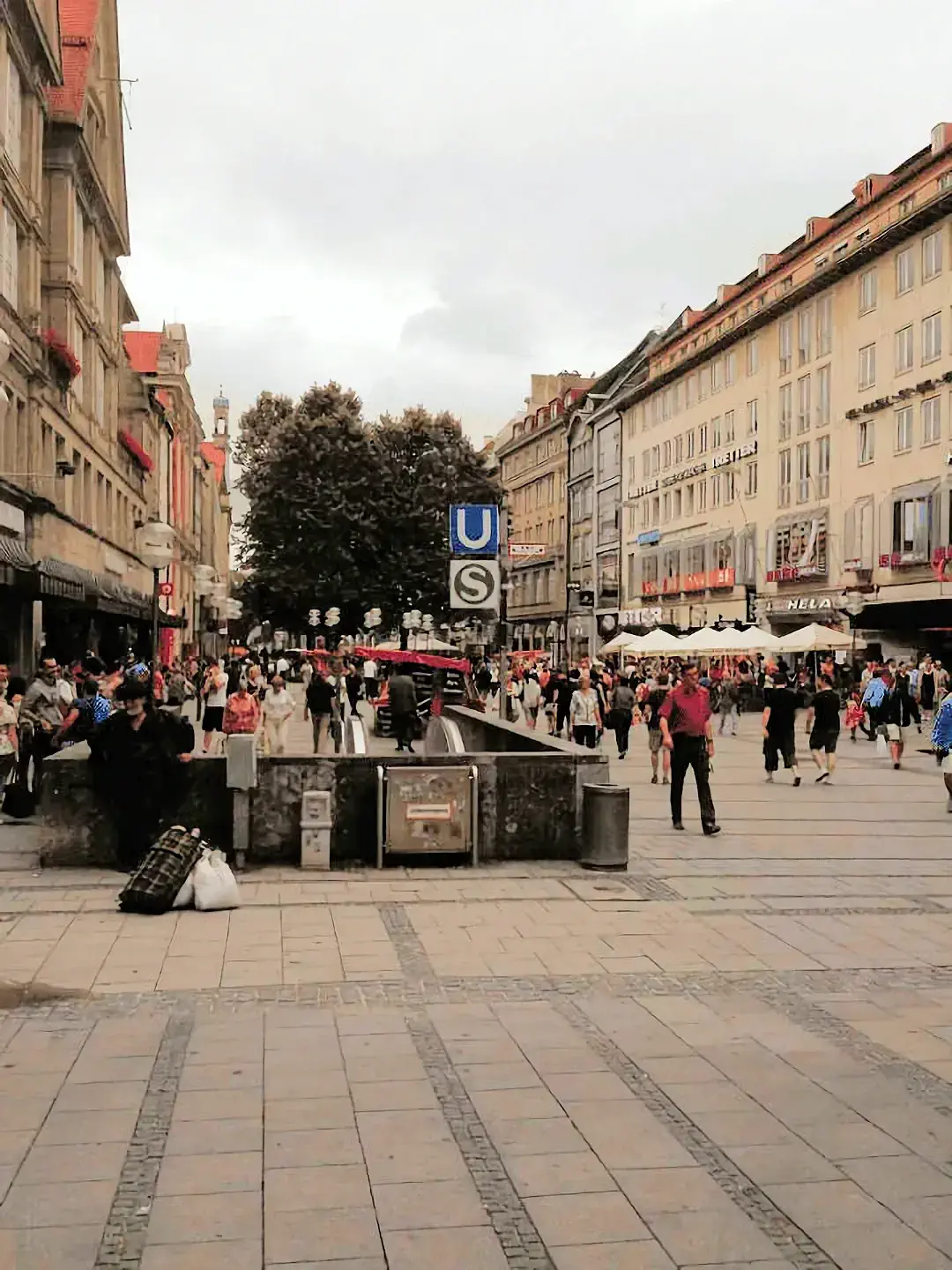
Another major advantage of Munich is its world-class public transportation system. With the city’s extensive network of U-Bahn (subway), S-Bahn (suburban trains), trams, and buses, there’s no need for a car. In fact, the heart of Munich, known as Marienplatz, is a pedestrian-only area, ensuring a calm and accessible environment for visitors. The transportation system is incredibly convenient, and one ticket is valid for all forms of public transportation—whether you’re traveling by train, tram, or bus. This seamless system makes getting around the city simple and stress-free, whether you’re exploring Munich’s historic old town or heading to nearby attractions.
In Munich, you’ll find the perfect balance of rich cultural experiences, outdoor activities, and family-friendly attractions, all set within a city that’s known for its warm hospitality and easy-to-navigate infrastructure. Whether you’re exploring the iconic beer gardens, admiring the stunning architecture, or reflecting on the city’s poignant history, Munich is a destination that offers something for everyone. Our visit not only allowed us to reconnect with old friends but also gave us the opportunity to show our son the unique blend of past and present that makes Munich one of the most beloved cities in the world.
Munich, the capital of Bavaria, blends centuries of tradition with a dynamic modern spirit. Known for its grand squares, world-class museums, and lively beer gardens, the city also serves as a hub for technology, business, and the arts. From the spectacle of Oktoberfest to everyday Bavarian culture, Munich offers visitors a unique balance of history, innovation, and charm. The following frequently asked questions highlight what makes this city such an essential stop in Germany.
Yes, Munich is the southernmost major city in Germany, but it is farther north than any major U.S. City (excluding Alaska).
Munich's Technische Universität (Technical University) has four-story slides to help students get to class faster. Also known as Germany’s "Entrepreneurial University"—over 1,000 startups launched.
Old Town Munich closed down it’s major streets For The 1972 Olympics to pedestrians only and they have remained that way ever since.
The Englisch Garden in central Munich has beer tents, restaurants and a clothing optional area. It is also one of the World’s Largest Urban Parks. It is even larger than New York's Central Park. It features beer gardens, scenic walking trails, and even a surfing wave on the Eisbach River.
Yes, Munich is home to the oldest cinema in the World - the Neues Kino Gabriel. . It first opened in 1907.
Yes, Munich is Built on Over 7,000 Underground Rivers, you can still see parts of these underground water channels near Maximilianstraße and Hofbräuhaus.
Yes, Beer is Legally Considered Food in Bavaria, it is officially classified as a staple food, thanks to the 500-year-old German Beer Purity Law (Reinheitsgebot), which allows only water, hops, malt, and yeast in beer production.
Munich’s Name Means "By the Monks" - The name "München" comes from the Old High German word Munichen, meaning "by the monks". The city was founded by Benedictine monks, whose influence remains visible in the city's symbols and architecture.
No, Munich is not the birthplace of pretzels, but it is strongly associated with them as the capital of Bavaria and a region where they are a staple. The origin is often attributed to European monks in the early Middle Ages, possibly in Italy or southern Germany, with the first recorded depictions appearing in the 1100s.
Munich is the birthplace of Weisswurst - The pretzel (Brezn), a symbol of Bavarian culture, and Weisswurst (white sausage), a traditional Bavarian dish, both originated in Munich. The Weisswurst tradition includes eating it before noon, paired with sweet mustard and a wheat beer.
The first Oktoberfest was held in 1810 to celebrate the wedding of Crown Prince Ludwig (later King Ludwig I) and Princess Therese of Saxony-Hildburghausen.
Bavaria Film Studios is one of the largest in Europe, where classics like The NeverEnding Story and Das Boot were filmed. There has been a large number of movies or TV shows filmed in Munich, click here to view the complete list on the IMDB website.
Munich is famous for Oktoberfest, the world's largest beer festival, its deep-rooted beer culture, and its historic beer halls like the Hofbräuhaus. The city is also known for the iconic BMW brand, with its global headquarters and attractions like the BMW Welt. Visitors also enjoy Munich's impressive architecture, including the Marienplatz and Frauenkirche, and its beautiful green spaces, such as the famous English Garden, which features a unique river surfing spot.
Yes, Munich is widely considered one of the world's most walkable cities, featuring excellent public transport, pedestrian-friendly layouts, numerous car-free zones, and extensive green spaces, making it easy and enjoyable to explore on foot. Key areas like the Old Town (Altstadt) are ideal for walking, with most major attractions within easy reach. The MVV system covers a very large percentage of Munich.
Marienplatz is a pedestrian-only zone and the central starting point for the city's pedestrian areas. It serves as a popular public square, meeting place, and transportation hub in Munich's city center.
To get from Munich Airport (MUC) to the city center, you can use the S-Bahn train lines S1 or S8, which take about 40 minutes and run every 10-20 minutes. Other options include the Lufthansa Express Bus (45 minutes, roughly every 20 minutes), or taxi/Uber, offering a faster but more expensive journey of 25-35 minutes.
Munich is famous for its hearty Bavarian cuisine, featuring iconic dishes like Weisswurst (white sausage) served with sweet mustard and a pretzel, slow-roasted Schweinshaxe (pork knuckle), Käsespätzle (cheese noodles), and the fluffy shredded pancake Kaiserschmarrn. Visitors can also enjoy local specialties such as rich beer garden food with large pretzels and sausages, hearty potato dishes like Kartoffelsalat, and regional cheeses.

A Munich Card is the perfect way for visitors to save money, explore effortlessly, and experience the best of Bavaria’s capital. This all-in-one city pass offers unlimited access to public transportation, making it easy to travel between top attractions like Marienplatz, Nymphenburg Palace, and the BMW Museum. With exclusive discounts of up to 70% on over 100 attractions, museums, and tours, the Munich Card provides incredible value for sightseeing enthusiasts. Enjoy savings on Oktoberfest tours, river cruises, and guided excursions to Neuschwanstein Castle, along with discounts at popular restaurants and shops. Whether you're visiting for the rich history, world-class museums, or iconic beer gardens, the Munich Card helps maximize your trip while staying within budget. Perfect for solo travelers, couples, and families, this pass ensures a stress-free and affordable Munich adventure!
Click the Card Image to go to their website.
On this European Driving trip, we had been in Annecy, France for most of a week and our next stop was Munich. Our drive there took us through Switzerland via the E25/E27 and E60 allowed us to cross into Germany at the southern end of the Bodensee. We drove north on the E60, and then eastward to Munich on the E54.
And this begins the portion of the trip, where Suzette (our Tom-Tom mapping device) really earned her stripes. We had rented a condo, in an area that would give us easy access to not only the subway, but to bus & tram service as well. This condo unit had underground parking, but we were not familiar with the streets there.
The first issue that arose, is that our Tom-Tom device insisted on taking us to Klenzestraße, as though it was a two way street, which it was not. Since we had an excellent Munich street map, we were able to navigate our way around the block, and to drive into the street with the correct driving orientation. Getting back to our rental was a constant challenge throughout the week, complicated by the direction we would re-enter Munich as each day trip was over.
Google shows that (as of 10/11/2024) there are 730 hotels in Munich, Germany. This list includes all types, ratings, locations, etc. If you would prefer to conduct your own research, click here to view the Google Search Results list for "accommodations in Munich". Once you are on that Google Search Results page, you can then change the filters to resort the hotels list by price, # of stars, property type, etc. This is a very useful tool for when you are research planning a trip.
Below is what Google says are the "top five most popular hotels in Munich, Germany" based upon Google Review Ratings;
We took a different route to accommodations on this trip to Munich, we rented a very nice condo apartment (with secure underground parking) in the south side of Munich near the Gärtnerplatz area on Klenzestraße. We wanted to be near a Metro Station (U-Bahnhof Fraunhoferstraße) and less than one kilometer from Sendlinger Tor.
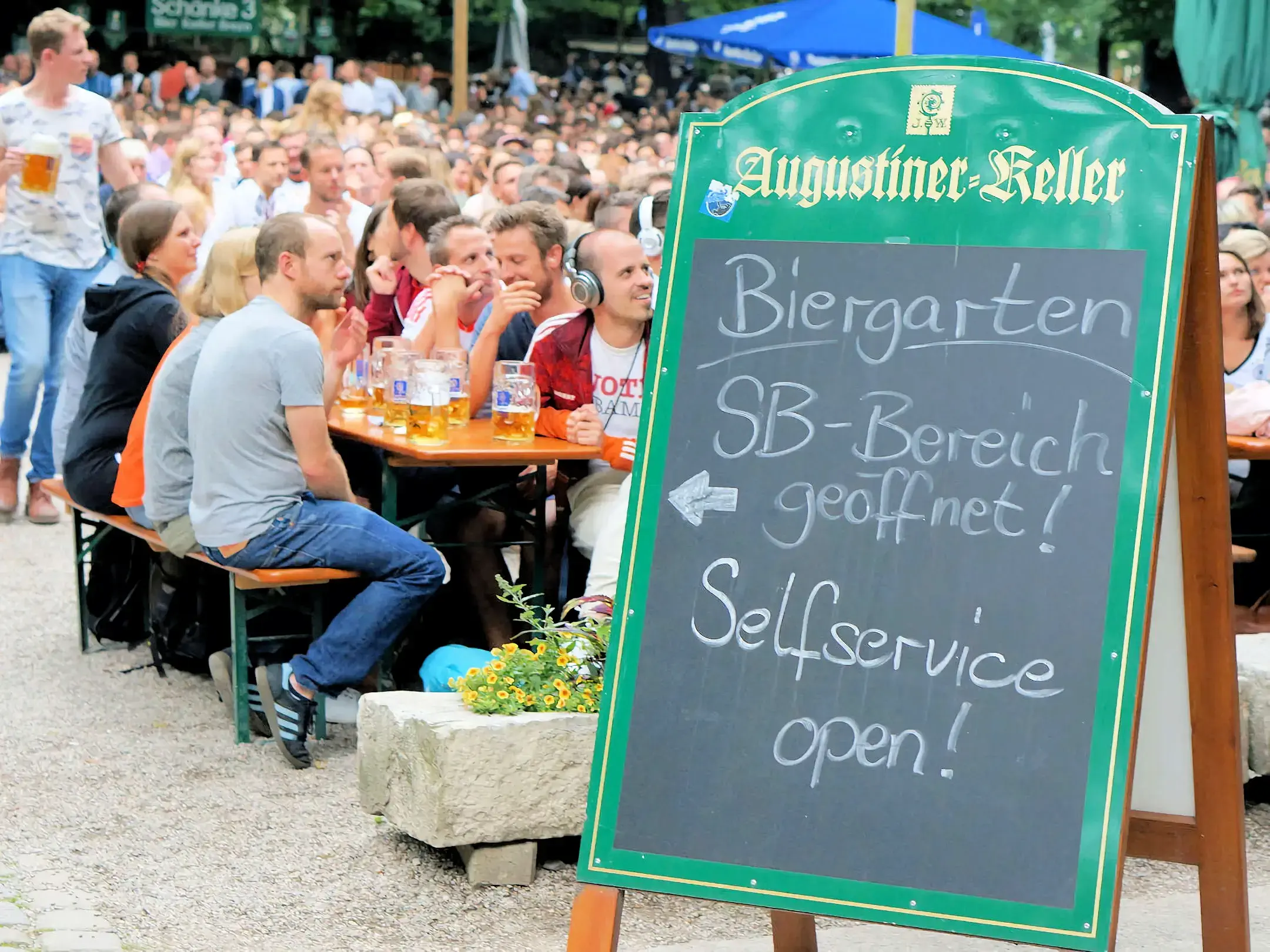
 Augustiner Keller Beer Garden
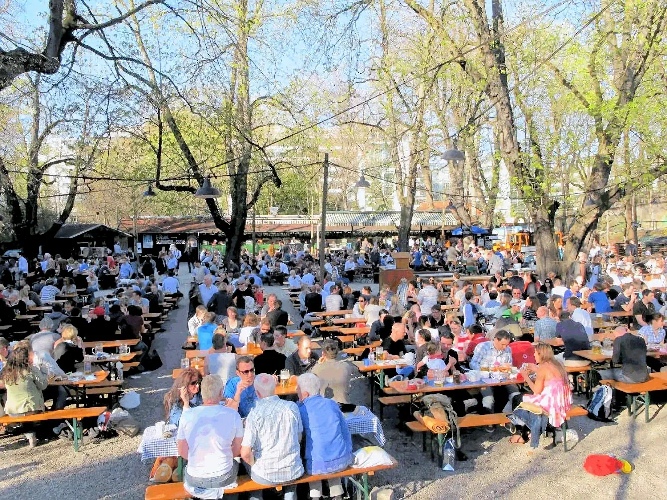
Our first outing was to the Augustiner Keller for dinner with old friends in Munich. Since it was Jeremy's first trip to a German beer garden, he was fascinated by the people, the food items, especially the HUGE pretzels, and the enormous amount of beer being consumed, etc. Augustiner-Keller with about 5,000 seats is the third largest beer garden in Munich. The beer garden opened in 1812. Like most beer gardens there is a self-serviced area where guests are welcome to bring their own food in addition to a serviced area.
Short History of Beer Gardens: Beer Gardens were invented in Munich during the 19th century and there are now approximately 120+ of them in & around Munich. The beer garden concept was quickly embraced by the major breweries.
It is unknown which Munich brewery opened the first Bavarian Biergarten, but it is likely one of Munich's big six: Löwenbräu, Hofbräuhaus, Augustinerbräu, Paulaner, Hacker-Pschorr and Spaten. What is known is that they developed in the Kingdom of Bavaria in the 19th century.
The next day we visited another friend in Munich that we had worked with in the 1980's. He had started a new Chauffeur Service Company (First Class Chauffeur Service), and offered to take us around the city in his new Volkswagen Phaeton. He spent the day with us, chauffeuring us around town, this was an interesting way to see Munich, and even though I have been there a huge number of times, going around the city with someone who lives there and knows how to drive there, is a treat!
More Info for Munich Beer Gardens
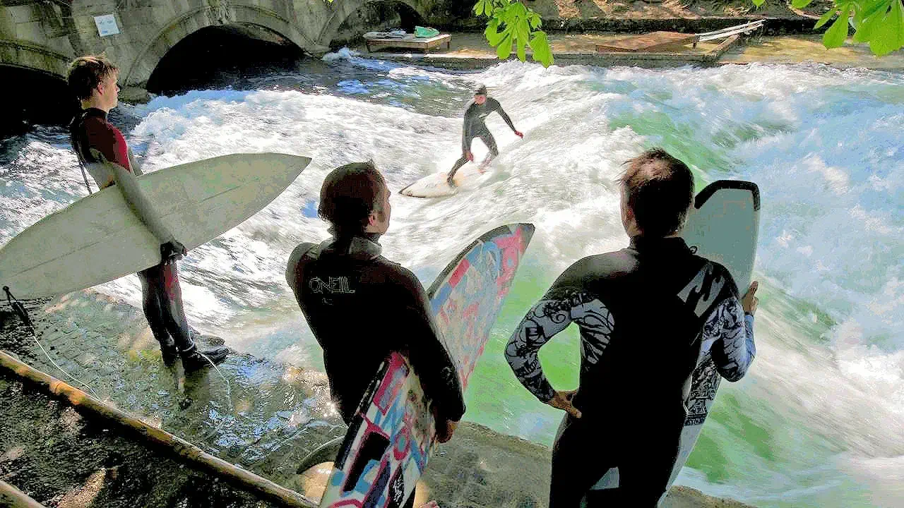
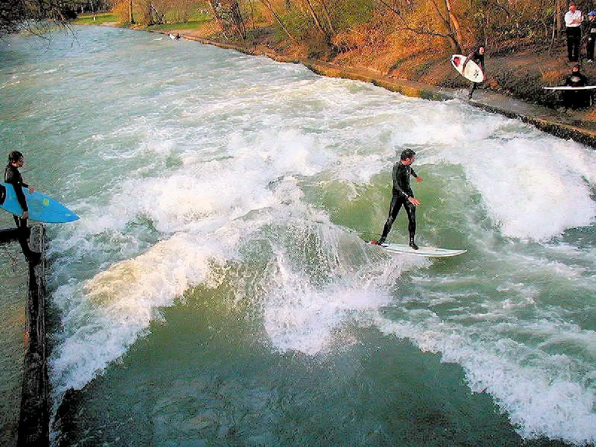
Our German friend started the tour, by taking us by the world famous Eisbach River surfing spot (an artificial stream that runs through the English Garden). Many years ago as Munich grew, the old river channel was forced into an underground tunnel, which allowed the city of Munich to "grow" over the tunnel. And this produces a river outlet spot with considerable water pressure, as shown in these pictures.
The surfers line up on the bank, and step in as the previous surfer steps out, or falls off. It is truly amazing to watch, as these guys are seriously good surfers and they put on a great show! This is not a spot for surfers who are not extremely experienced, because one does not paddle to catch a wave, you jump on your board and the wave propels you immediately!
If you want to see some interesting videos of people surfing the Eisbach, click here to view an existing video (thanks to the video owner GP McGee).
More Info for the Eisbach River
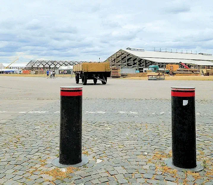
The next stop was at the Oktoberfest grounds, where workers were busy constructing the festival tents that will house each "tent". Back in the day, each tent represented a Munich Brewery, however this is no longer the case. Nonetheless, each tent will offer food, beer and ompah bands to sing along with! And just for the people who do not like beer, there is usually a "wine tent" as well.
The first image above (left side), shows the Theresienwiese as it is being prepared for the Oktoberfest festival, this picture was taken in July and the festival starts in the last week of September - so it gives you a good idea of how much work remains to be c ompleted. In the center of image #1, you can see the "tents" being constructed which will house the beer gardens and restaurants. If you do not understand the use of the word "tents" in relation to the Festival, I suggest you click the "tents link" to go to Wikipedia and learn what it means.
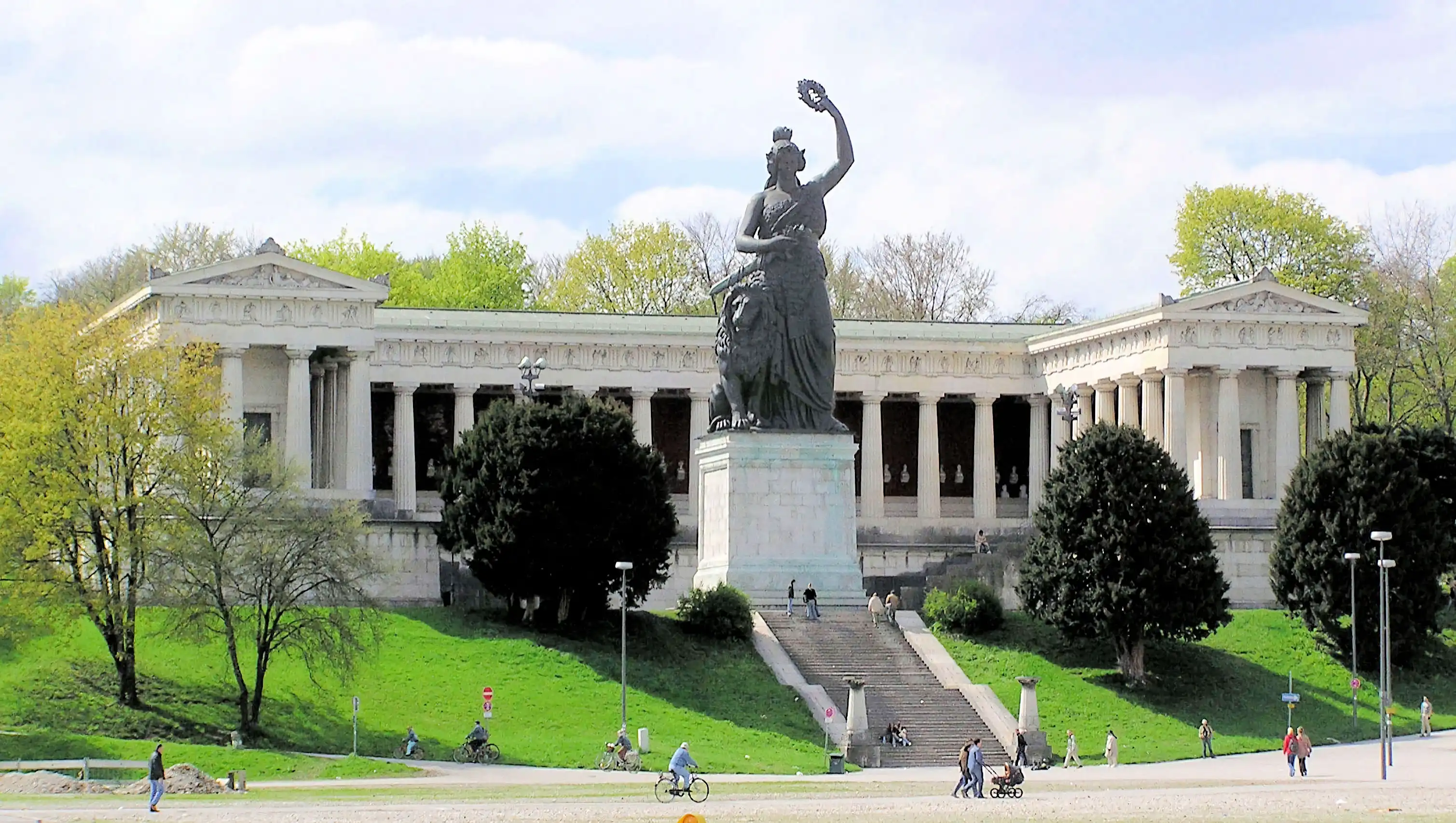
The second image above (right side) is of the "Ruhmeshalle & Bavaria Statue" (located on the west side of the Theresienwiese) which is part of an ensemble which also includes a hall of fame (Ruhmeshalle) and a stairway. It was commissioned by Ludwig I of Bavaria, with the specific design being chosen by competition. It was cast at the Munich foundry of J.B. Stiglmair between 1844 and 1850 and is the first colossal statue since Classical Antiquity to consist entirely of cast bronze. It was and is up to the present day considered a technological masterpiece. Because of its size it had to be produced in several parts; it is 18.52 metres (60 ft. 9 in.) high and weighs about 87.36 tons. It rests on a stone base which is 8.92 (28 ft.) metres high.
NOTE: Image # 2 is from Wikipedia, however, the image does not have an author, so no accreditation is offered herein.
Quick Oktoberfest History Lesson: Oktoberfest started in 1810, the original Fest was the celebration of a Bavarian royal wedding. Princess Teresa (Therese) of Bavaria (1792-1854) had married crown prince Ludwig I (later king of Bavaria) on the evening of October 12, 1810. The next day, the city began celebrating the wedding with various activities, including concerts, parties, balls, and even a horse race on the 17th. It all went so well that the Bavarian royal family decided to hold another race a year later, beginning the Oktoberfest tradition. In fact, this is why the area where the Oktoberfest is held is called "Theresienwiese". Prince Teresa and Prince Ludwig were actually married at the Theresienwiese.
Each year there are 14 large beer tents with indoor seating between 700 to 8,400 persons, and only the breweries located in Munich (Spaten, Paulaner, Hofbräu, Hacker-Pschorr, Franziskaner, Spaten, Löwenbräu and Augustiner) are allowed to setup tents at the Oktoberfest.
The tents are non-permanent structures which are set up each year anew starting as early as July. For more information regarding Oktoberfest tents, click here to read the Wikipedia article.
In addition to the large tents, there are also the smaller tents, which are mainly the rotisserie chicken stands like Wienerwald, Cafe Kaiserschmarrn (Rischart), Vinzenz Murr, Poschners, Heimer, Cafe Mohrenkopf, Bodos café tent, the Inn in Schichtl and the Ammer chicken and canard rotisserie that since 2000, only sells organic products. These smaller tents seat 60 to 450 persons each.
To view the Wikipedia Article where the above history came from, click the Wikipedia link below.
More Info for the Oktoberfest Grounds "Theresienwiese"
Having worked in Munich for several years while with Siemens, I was lucky enough to attend Oktoberfest many times. What surprised me early on — and continues to surprise many first-time visitors — is that Oktoberfest is not just a beer festival. It’s a massive Bavarian cultural event rooted in tradition, and it's worth understanding a bit before you go.
Oktoberfest is one of the world’s largest folk festivals — and it’s much more than just beer. Go with a bit of local context, and you’ll enjoy it like a true Bavarian.
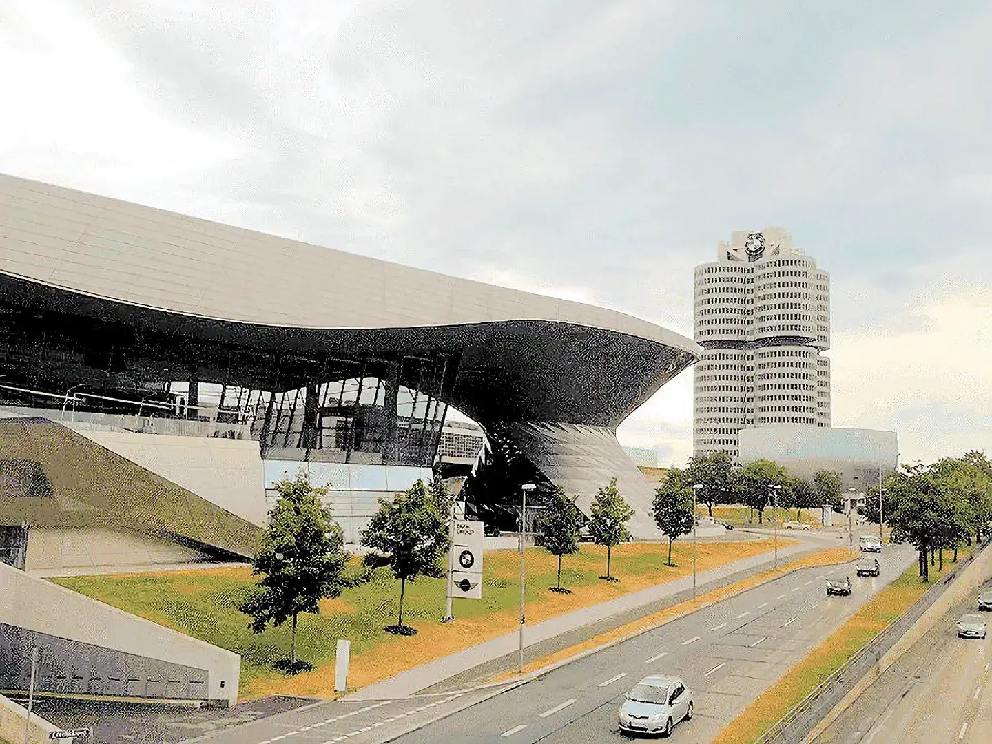
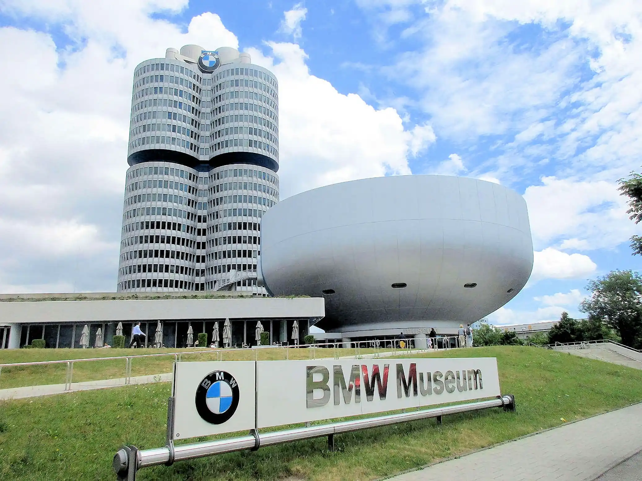
Our next stop, was the BMW museum next door to the 1972 Olympic Center area. This is a fascinating museum, and it contains a number of BMW cars (including the Mini Cooper) and motorcycles.
In image # 1 that building on the left is the BMW museum, and the building on the right, is the BMW headquarters building.
It is simple to travel to the BMW Museum, for example from Marienplatz take the U3 subway. Taxi and/or uBer is a brief ride, or you could easily walk as it is only 3.4 miles. No matter how you arrive, the museum is an interesting visit, and then the Olympic Park is right next door.
NOTE: Image # 2 is the property of Arnaud 25 via Wikipedia.
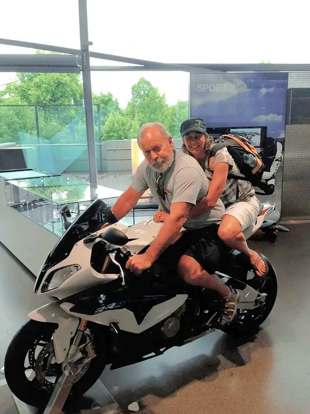
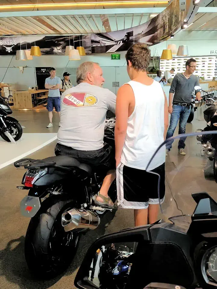
This is the BMW K-1300-S (found in the BMW Museum) which I initially thought was going to be my next motorcycle. Instead, I wound up with a Harley-Davidson VROD (another story). This BMW has tremendous power and gets amazing reviews, so only time will tell if I made the right choice.
As you can see, Celeste and I were trying out the "riding comfort" of the BMW, and then I was explaining to Jeremy what I liked about this BMW motorcycle.
More Info for the BMW Museum
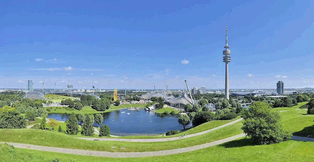
After our BMW museum tour, we walked across the autobahn on the pedestrian walkway to the Olympic Park. We rode up to the top of the Olympic Tower (right center of picture) so that we could show Jeremy the amazing view of Munich from that height.
You can see the BMW Headquarters building in the right side of this picture, gives you a good idea of the proximity of the Olympic Center to the BMW complex. Not a huge walk, Google Maps indicates approximately 500 meters if you use the footbridge across the Georg-Brauchle-Ring freeway.
NOTE: Image # 1 is the property of Taxiarchos228 via WikiMedia Commons. All other images (unless otherwise noted) are the property of Just Traveling Thru, LLC.
Some Park History: The Olympiapark München is an Olympic Park which was constructed for the 1972 Summer Olympics. Located in the Oberwiesenfeld neighborhood of Munich, the Park continues to serve as a venue for cultural, social, and religious events, such as events of worship. It includes a contemporary carillon. The Park is administered by Olympiapark München GmbH, a holding company fully owned by the state capital of Munich.
Click our Olympic Park Wikipedia link below to read the full article about the Munich Olympic Park.
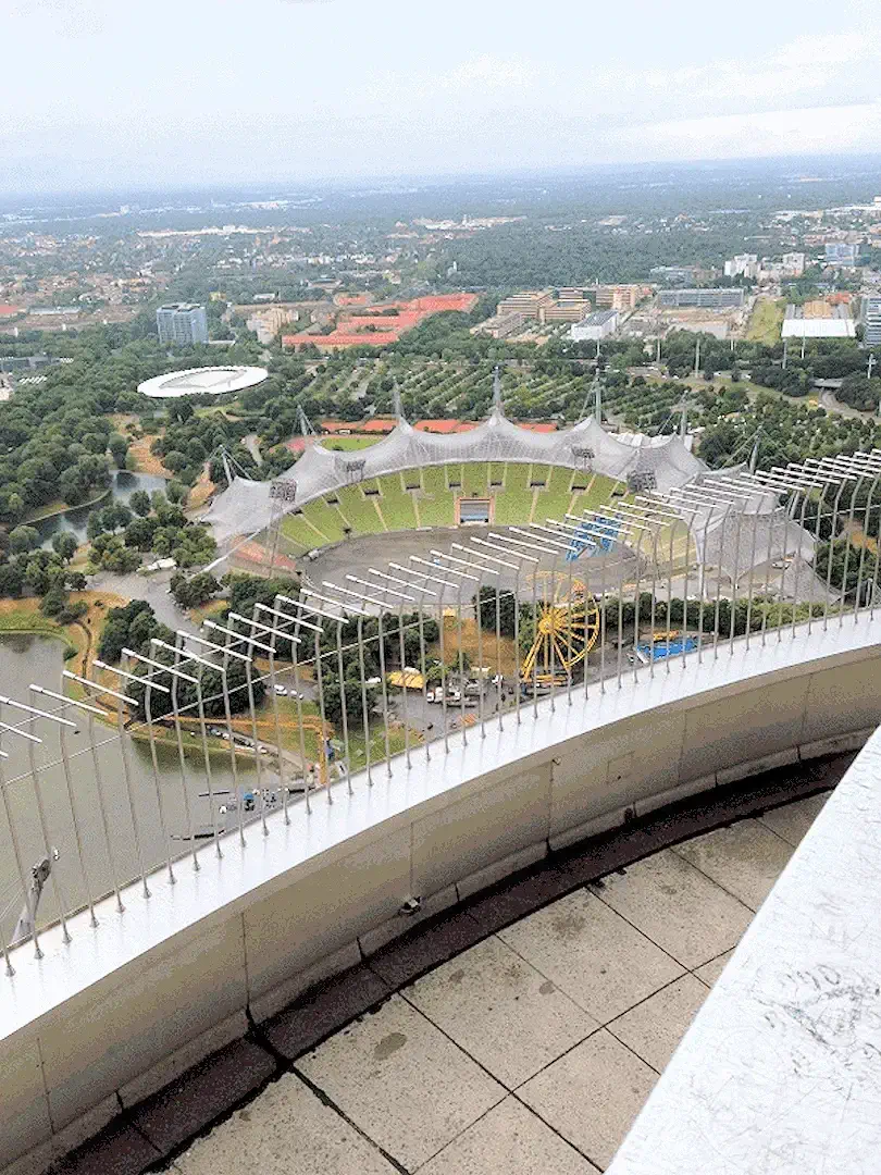 Olympic Soccer Stadium view from the Tower
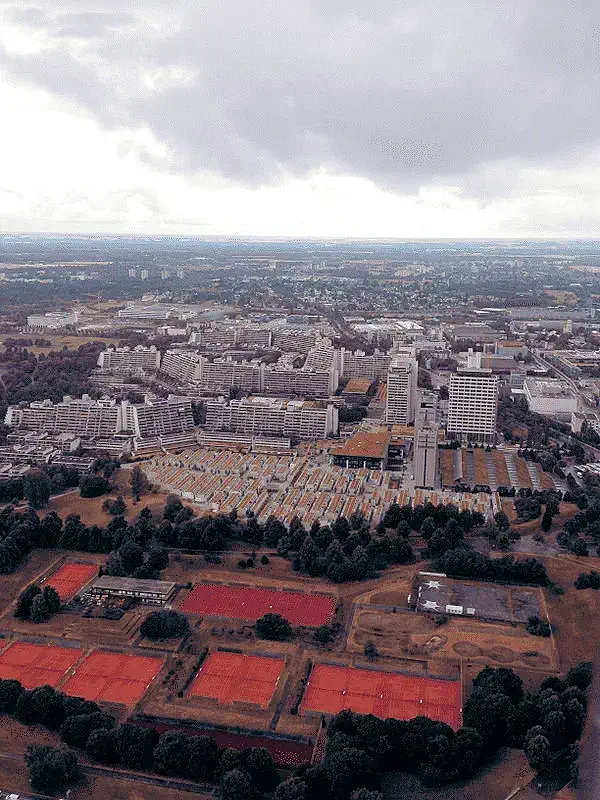 Looking South from the Olympic Tower
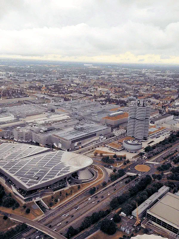 View of the BMW Museum from the Olympic Tower
As seen from the top of the tower. For those of you who watched the 2013 World Cup Final, this stadium was completely full of soccer fans, watching the final on several jumbo-tron monitors erected for the fans to watch the finals.
DIRECTIONS: As I previously mentioned, our good friend dropped us off at the BMW Museum, and then we walked across the footbridge to the park. If however you are at Marienplatz, you have the choice of riding either an S-Bahn or a U-Bahn to get to the Olympia-Einkaufszentrum Station which is the closest subway station to the park. In fact, we rode the U-Bahn (U-3) back to Marienplatz after our park exploration was completed.
More Info for Munich's Olympic Park
We walked back to the Olympia-zentrum U-Bahn Station and rode the U3 back to Marienplatz Station. This is a large 4 level station, where the S-Bahn (S1, S2, S3, S4, S6, S7 and S8) lines intersect with the U-Bahn (U3 and U6).
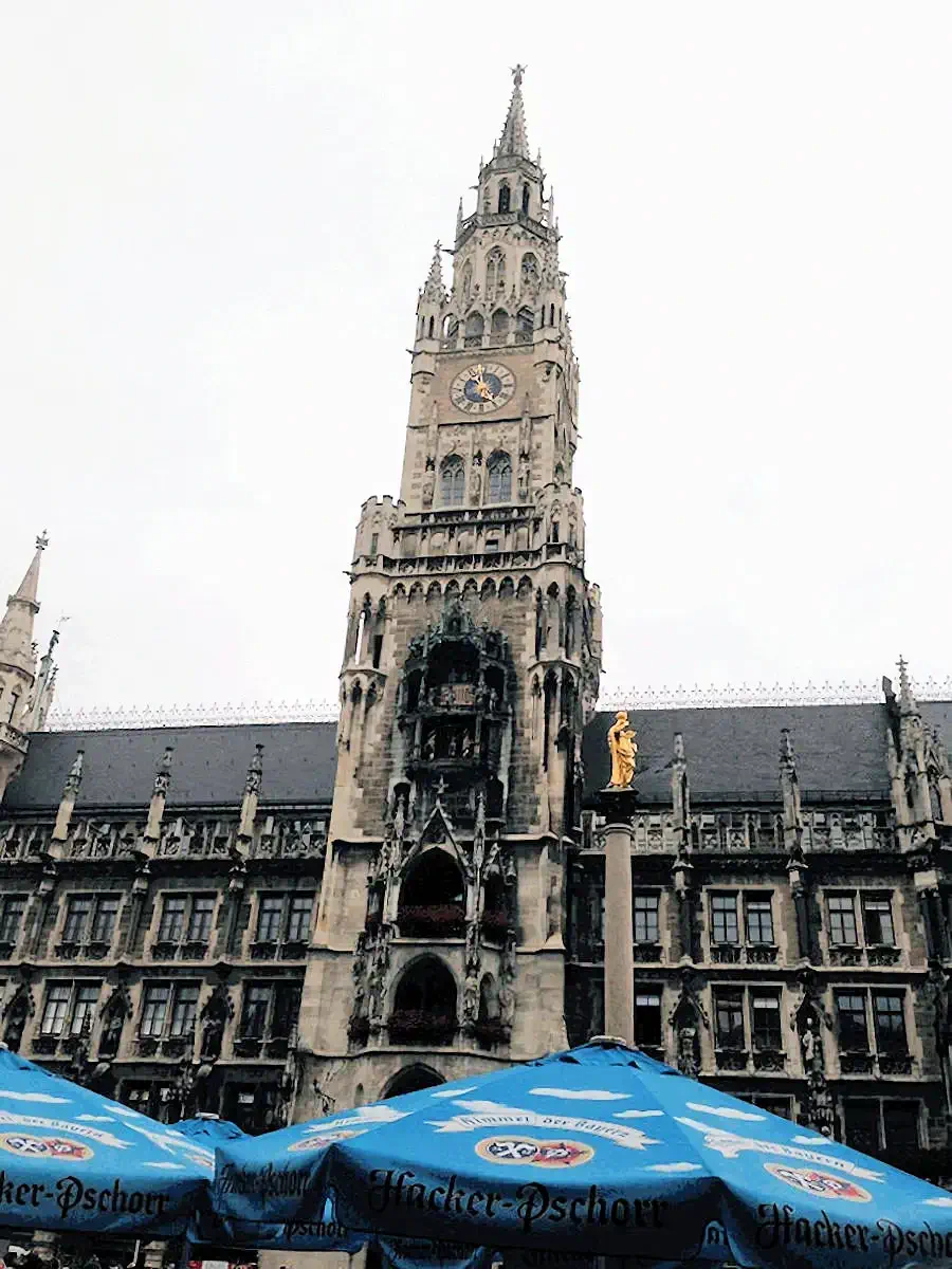
We exited the station and strolled through Marienplatz (pedestrian area) to watch the glockenspiel march when the hour ticked over.
Not sure that you can tell from these pictures, that it had just stopped raining. Which, given the heat wave that was still over Europe, cooled things off nicely.
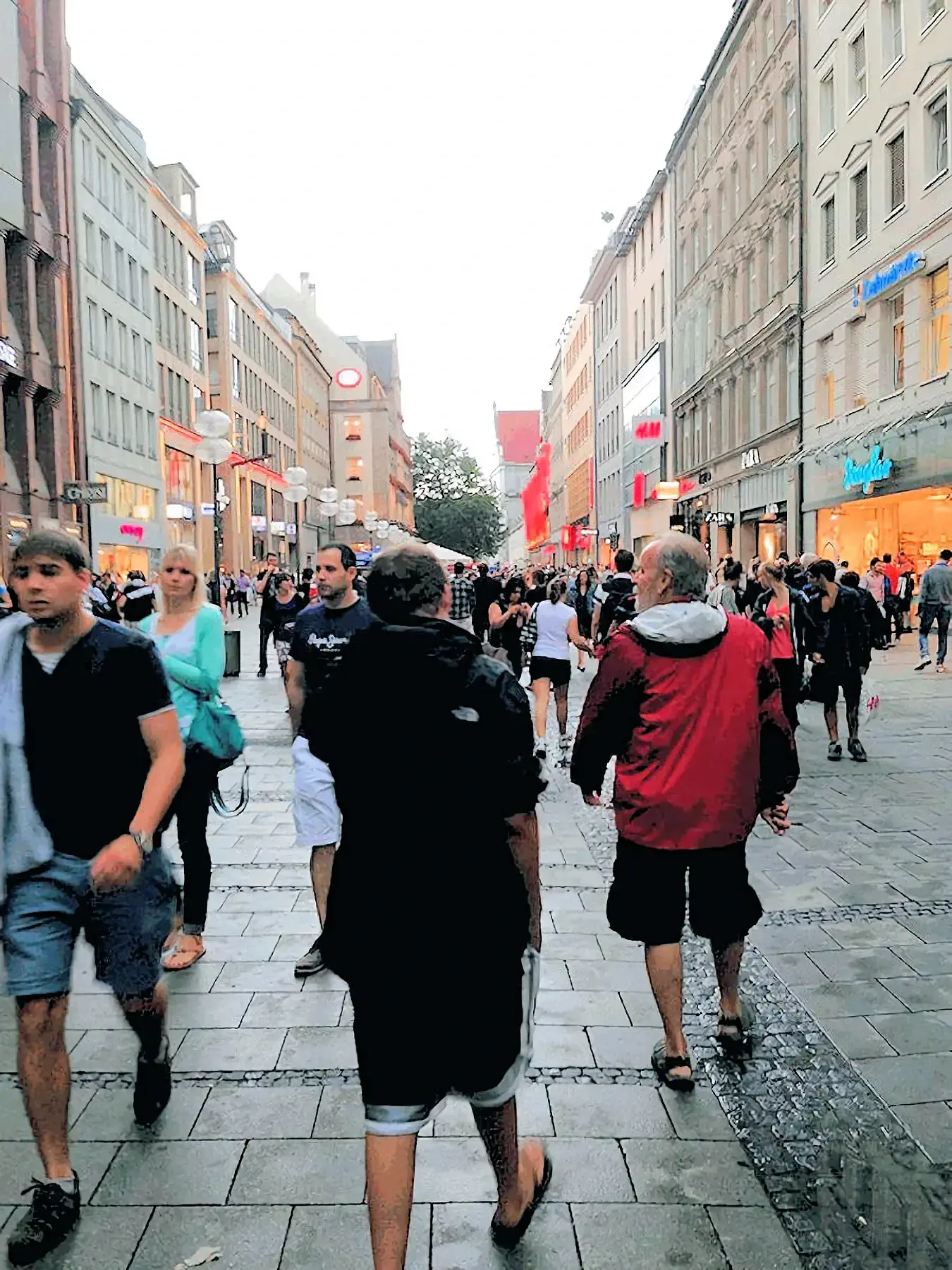
Strolling along in Marienplatz in central Munich, and you can see how crowded it is? This is typical for a summer day.
We were looking for a place to purchase an afternoon snack and an iced coffee - and fortunately for us, we found one quickly.
More Info for Marienplatz Area
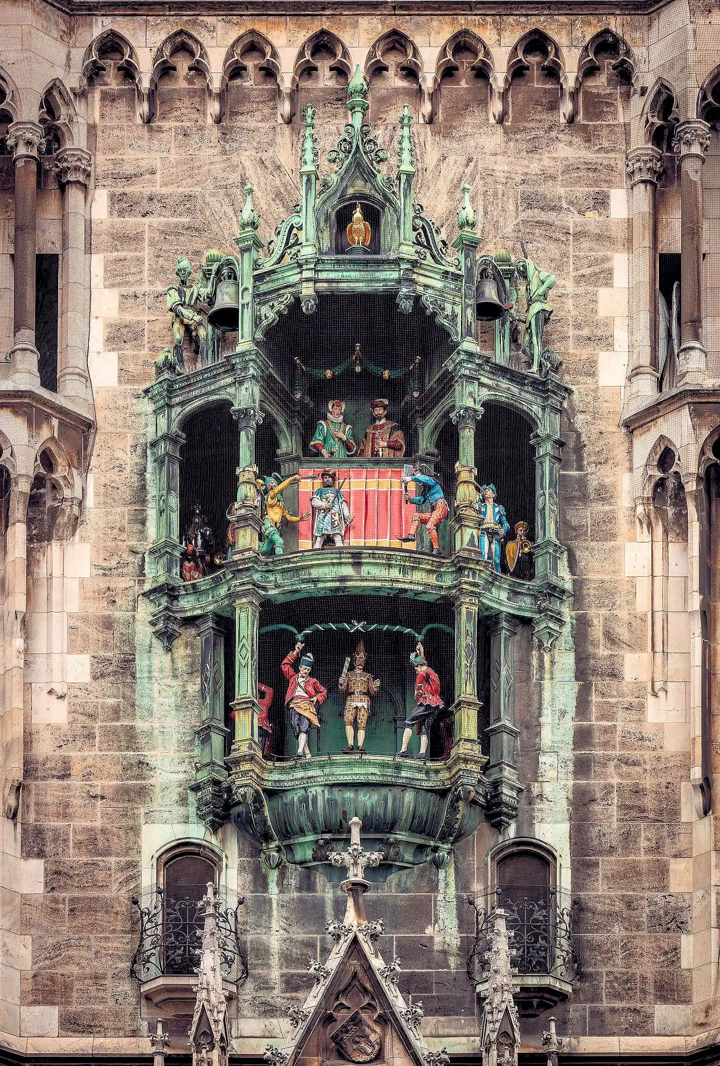
Every day at 11 a.m. and 12 p.m. ( as well as 5 p.m. in the summer) the glockenspiel chimes and re-enacts two stories from the 16th century to the amusement of mass crowds of tourists and locals. It consists of 43 bells and 32 life-sized figures. The top half of the Glockenspiel tells the story of the marriage of the local Duke Wilhelm V (who also founded the world famous Hofbräuhaus) to Renata of Lorraine.
In honour of the happy couple there is a joust with life-sized knights on horseback representing Bavaria (in white and blue) and Lothringen (in red and white).
The Munich Rathaus Glockenspiel is a must-see attraction for any visitor to the city. This iconic clock, located in the heart of Marienplatz, features a captivating display of life-sized figures re-enacting historical scenes.
To experience this magical spectacle, you'll want to find a good spot in Marienplatz. Here's how people typically watch it:
NOTE: Image # 2 above is the property of Christoph Braun via Wikimedia Commons.
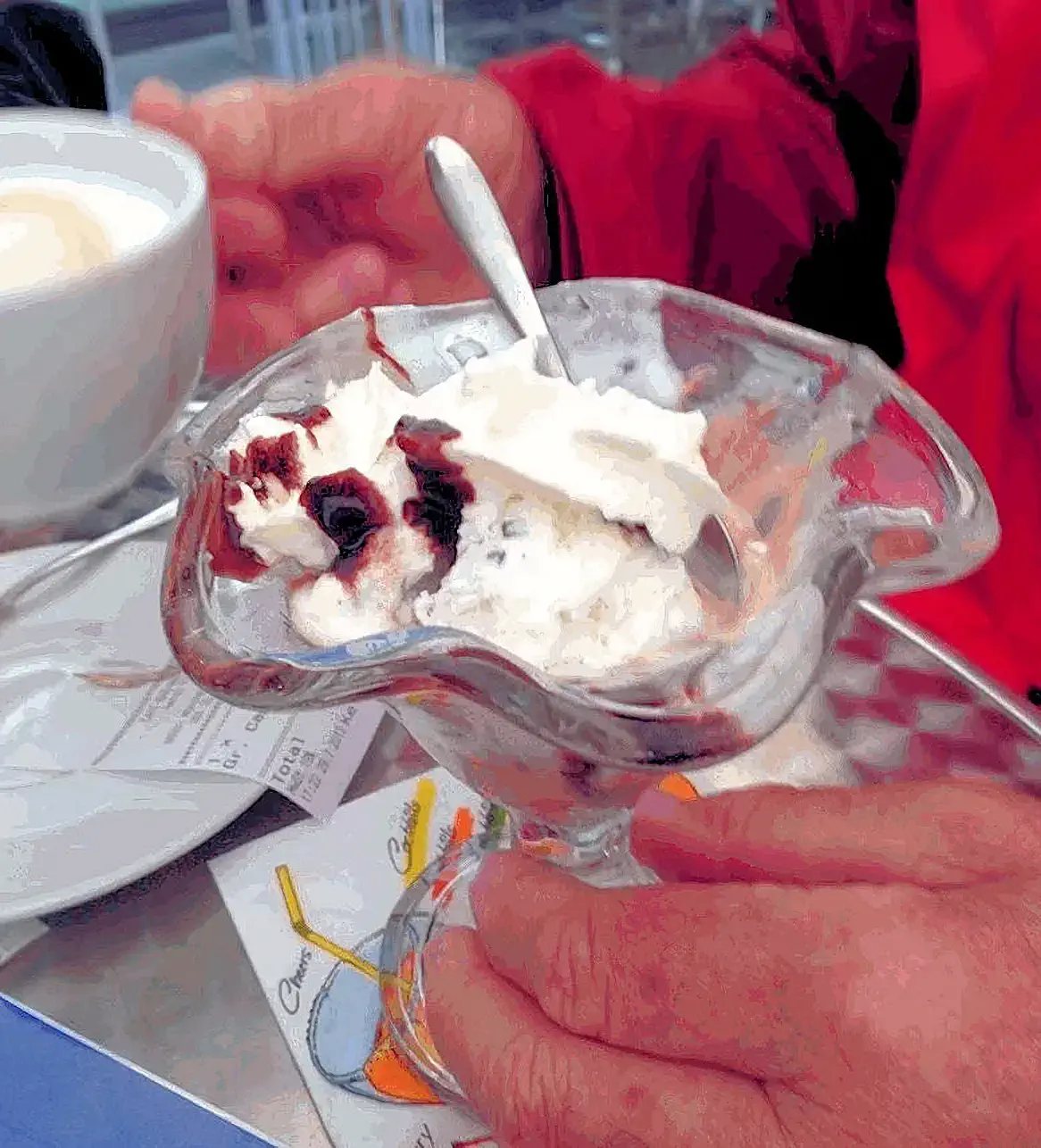 Ice Cream Break
We were "forced" to find various ways to deal with the heat, and discovered that ice cream worked very well to reduce the heat effects ! While trekking about, we found a great little ice cream shop, in an alley that led to a shopping area, just off Marienplatz (sorry we did not record the name of this shop). As we needed some afternoon "motivation", the ice cream was accompanied by a cappuccino and we were ready to keep on walking!
If you are anywhere near Marienplatz, you may want to view this Google Search Results list for "ice cream shops near Marienplatz".
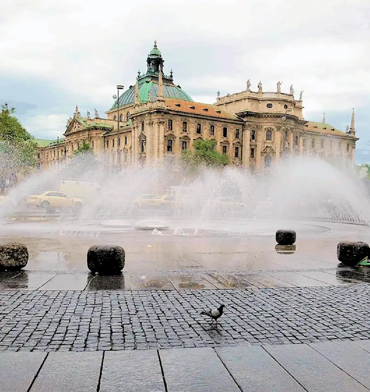 Karlsplatz Fountains
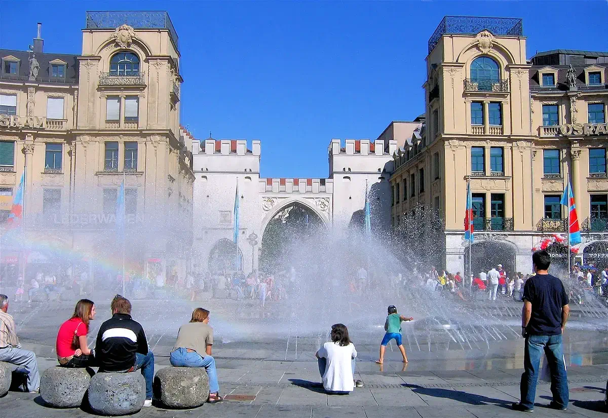 Karlsplatz Fountains
 Karlsplatz Fountains
We made our way to the western end of Marienplatz, strolling along Kaufingerstrasse and Neuhauser Strasse, two of Munich’s busiest pedestrian streets, filled with shops, cafes, and street performers. Our destination was Karlsplatz (Stachus), a bustling square that serves as a central hub for both locals and tourists. The square is always lively, and the large fountain in the middle draws a steady crowd, especially during warm weather when people gather to enjoy the refreshing spray of water.
Beyond the charm of the fountain, Karlsplatz is one of Munich’s major transportation intersections, where buses, trams, and the subway system all converge. It's a key gateway to explore different parts of the city, making it a convenient spot to catch a ride back to our apartment. The square’s energy, historic architecture, and the seamless blend of old-world charm with modern urban life make it a memorable stop during any visit to Munich.
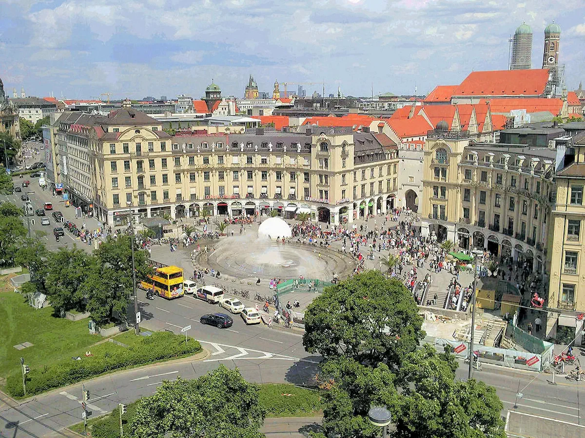
From this angle in image # 2, you can see a wonderful view of the Karlstor (which translates to "Karl's Gate") from the eastern side of Karlsplatz Square. The Karlstor is one of the original medieval gates that once formed part of Munich's old city fortifications. Built in the late 13th century, it was a key entry point into the city for travelers arriving from the west.
While the gate has undergone several restorations over the centuries, it remains an iconic landmark, marking the beginning of Munich's bustling pedestrian zone along Neuhauser Strasse and Kaufingerstrasse. The arched structure, framed by two towers, creates a striking contrast against the modern hustle and bustle of Karlsplatz.
For those of you familiar with Munich, this is a nice stroll through the center of the city, lined with shops, restaurants and other types of stores. In fact, there is a large shopping center underneath the Karlsplatz Square ( the "Stachus Passagen").
Image # 3 is a great picture of Karlsplatz from the western side of the square, you can see the fountains and bus stops. You might not be able to see the U-Bahn sign (to the right of the stairs in the lower right corner of the picture) but the station is just below the square. Munich Karlsplatz Station provides access to S-Bahn and U-Bahn trains and is one of the busiest stations in Munich.
More Info for Karlsplatz
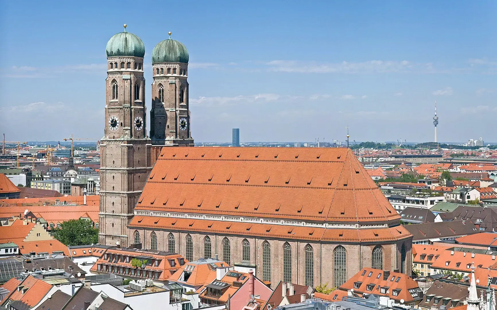 Frauenkirche
The twin spires church is the "Frauenkirche" which is a church that serves as the cathedral of the Archdiocese of Munich and Freising and seat of its Archbishop. More importantly, in the background are the Bavarian Alps. Beautiful isn't it?
The Frauenkirche was built in the late 15th century and has a unique architectural style that blends Gothic and Renaissance elements. It is famous for its stunning interior, which features intricate stone carvings, colorful stained glass windows, and an impressive organ that is considered one of the largest in Germany.
Some Frauenkirche History: Construction began in 1468, and when the cash resources were exhausted in 1479, Pope Sixtus IV granted an indulgence to complete the construction.
The two towers, which are both just over 98 meters (323 feet) tall, were completed in 1488, and the church was consecrated in 1494. There were plans for tall, open-work spires typical of the Gothic style, but given the financial difficulties of the time, the plans could not be realized. The towers remained unfinished until 1525.
This history info came from the Wikipedia Article, to read the entire article, click the Wikipedia link below.
More Info for Frauenkirche
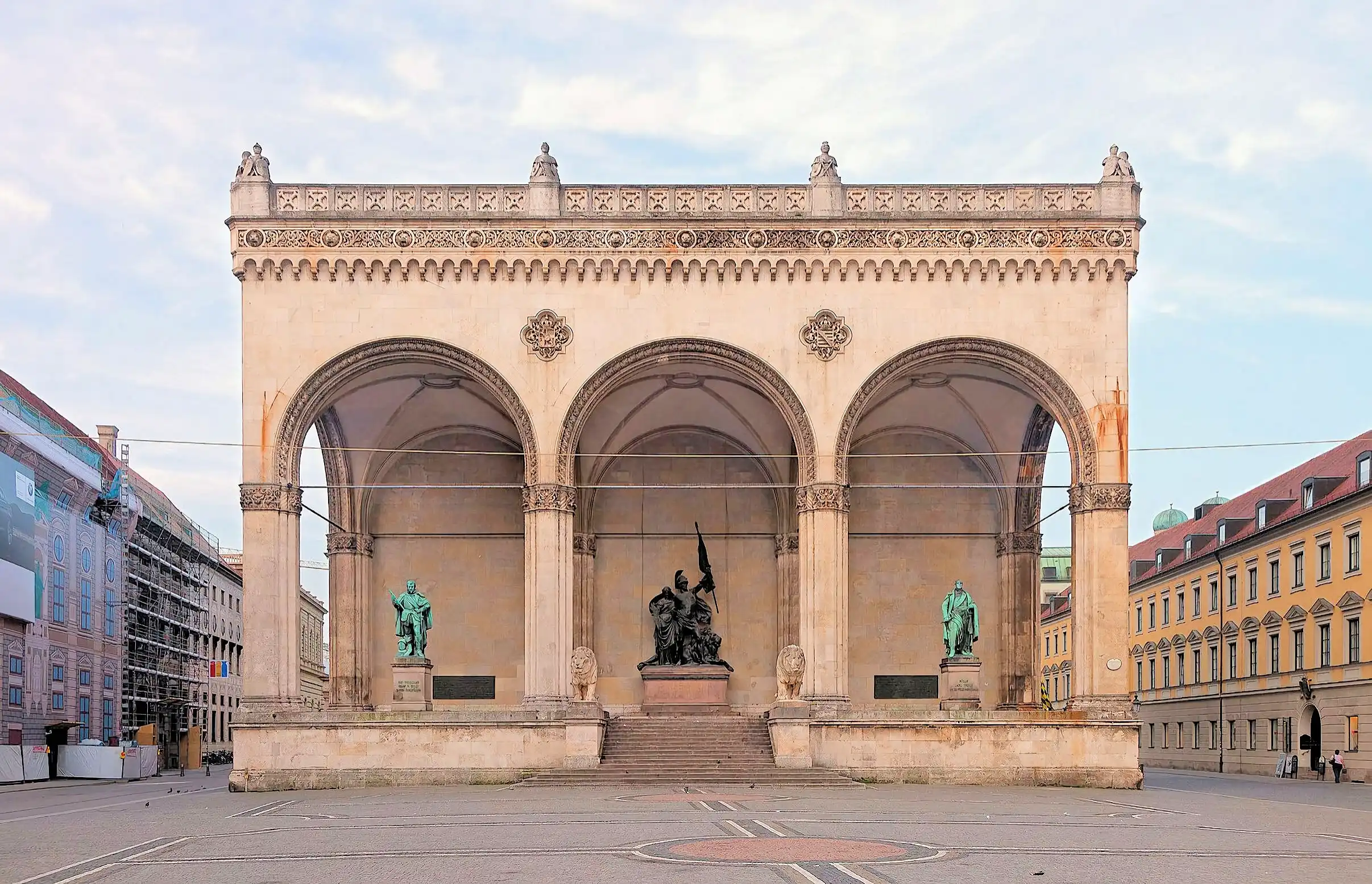 Feldherrnhalle
The Feldherrnhalle (Field Marshals' Hall) is a monumental loggia on the Odeonsplatz in Munich, Germany. Modelled after the Loggia dei Lanzi in Florence, it was commissioned in 1841 by King Ludwig I of Bavaria to honour the tradition of the Bavarian Army.
In 1923, it was the site of the brief battle that ended Hitler's Beer Hall Putsch. During the Nazi era, it served as a monument commemorating the death of 16 members of the Nazi party.
Some Feldherrnhalle History: The Feldherrnhalle was built between 1841 and 1844 at the southern end of Munich's Ludwigstrasse next to the Palais Preysing and east of the Hofgarten. Previously, the Gothic Schwabinger Tor (gate) occupied that place. Friedrich von Gärtner built the Feldherrnhalle at the behest of King Ludwig I of Bavaria after the example of the Loggia dei Lanzi in Florence.
In 1923, it was the site of the brief battle that ended Hitler's Beer Hall Putsch. During the Nazi era, it served as a monument commemorating the death of 16 members of the Nazi party.
This history info came from the Wikipedia Article, to read the entire article, click the Wikipedia link below.
More Info for Feldherrnhalle
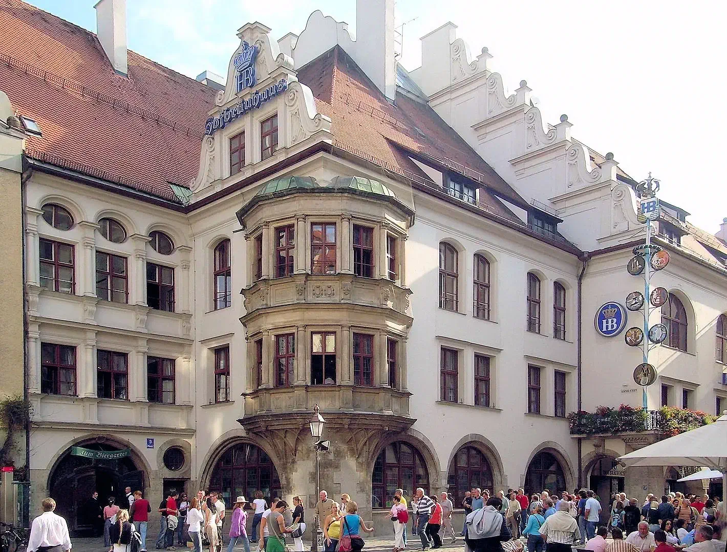 Hofbräuhaus am Platzl
Hofbräuhaus München: Munich’s Iconic Beer Hall
The Hofbräuhaus München is one of the most famous beer halls in the world, steeped in history and Bavarian tradition. Originally established in 1589 by Duke Wilhelm V of Bavaria, it served as the official brewery for the Wittelsbach royal family. In 1828, King Ludwig I opened its doors to the public, making it a beloved gathering place for locals and visitors alike.
A Historic Transformation
By the late 19th century, the demand for Hofbräu beer had outgrown the original space, leading to a complete renovation in 1897 by architect Max Littmann. During World War II, the building suffered extensive damage, with only the historic Schwemme (main beer hall) surviving the bombings. The painstaking reconstruction efforts culminated in the reopening of the Festival Hall in 1958, restoring the Hofbräuhaus to its former glory.
A Must-Visit Bavarian Experience
Today, the Hofbräuhaus is a lively hub of Bavarian culture, welcoming over 35,000 guests daily. Visitors can enjoy:
More Info for Hofbräuhaus am Platzl
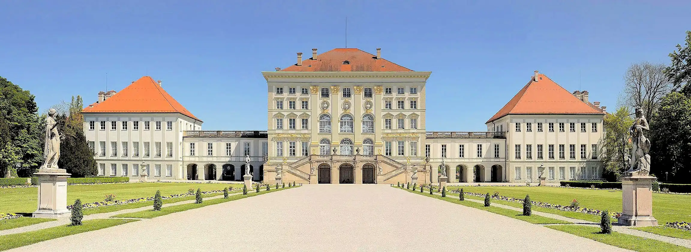 Nymphenburg Palace
Nymphenburg Palace (Schloss Nymphenburg), a stunning Baroque landmark, stands as one of Europe’s grandest royal residences. Located in Munich’s Neuhausen-Nymphenburg district, the palace was originally commissioned in 1664 by Elector Ferdinand Maria of Bavaria as a gift to his wife, Henriette Adelaide of Savoy, to celebrate the birth of their heir, Max Emanuel. Over time, it evolved into an opulent summer retreat for the ruling House of Wittelsbach and became a key symbol of Bavarian royalty.
One of Nymphenburg’s most striking features is its enormous scale. With a front width of 632 meters (2,073 feet) along its north-south axis, it surpasses even Versailles in sheer length! The sprawling design reflects the palace’s transformation under Elector Max Emanuel (1680–1726), who expanded the complex into its present-day grandeur.
Architectural & Artistic Highlights
The Nymphenburg Palace Park & Gardens
Beyond the palace, the Nymphenburg Park spans 490 acres, blending formal French gardens with natural English-style landscapes. It features:
Amalienburg – A masterpiece of Rococo elegance.
Pagodenburg – A Chinese-inspired retreat for relaxation.
Badenburg – A luxurious bathhouse with an early heated swimming pool.
More Info for Nymphenburg Palace
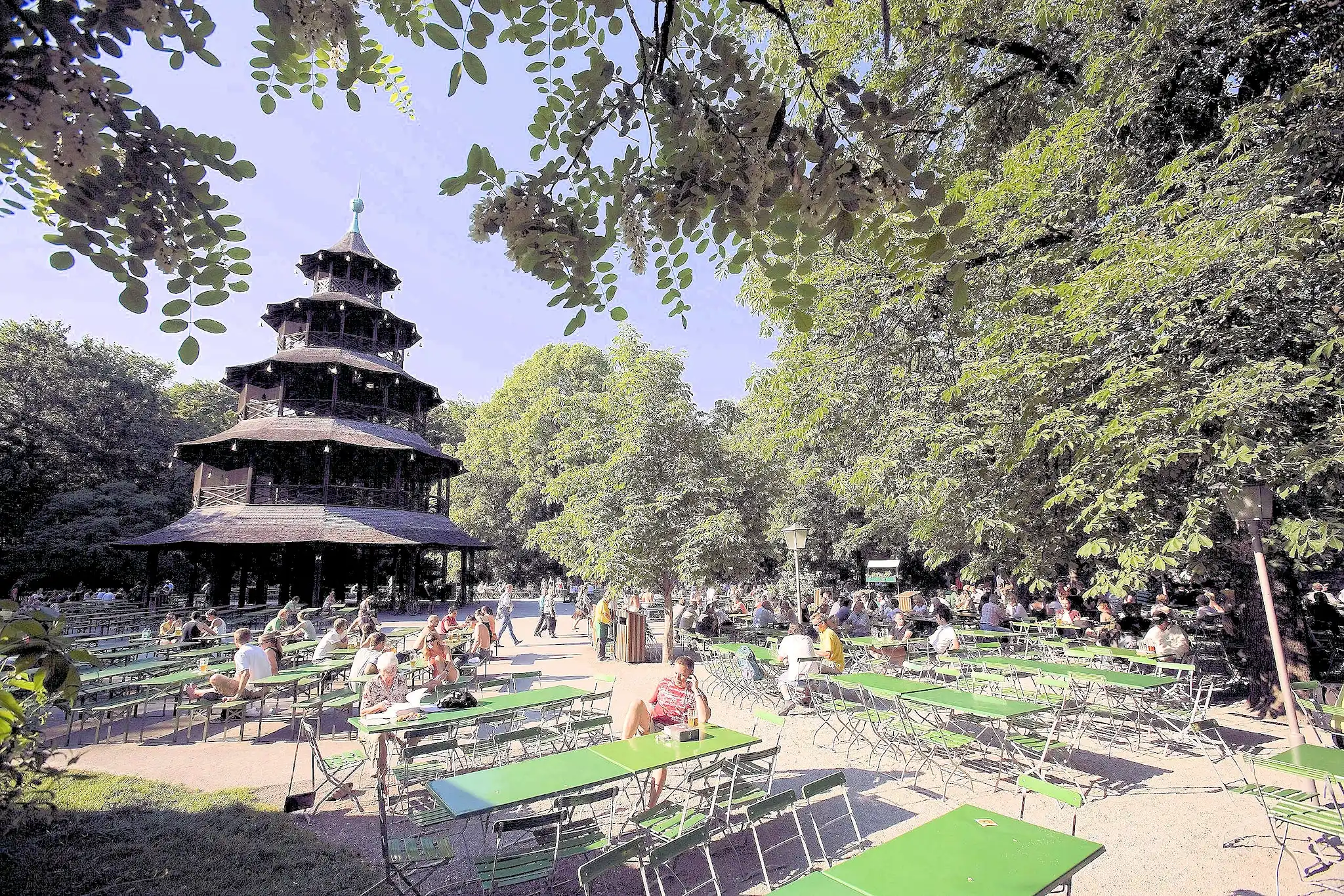 Englischer Garden Chinese Tower
This is a picture of the Chinese Tower in the English Gardens, a large public park in the centre of Munich, Bavaria, stretching from the city centre to the northeastern city limits. It was created in 1789 by Sir Benjamin Thompson (1753–1814), later Count Rumford (Reichsgraf von Rumford), for Prince Charles Theodore, Elector of Bavaria. Thompson's successors, Reinhard von Werneck (1757–1842) and Friedrich Ludwig von Sckell (1750–1823), advisers on the project from its beginning, both extended and improved the park.
With an area of 3.7 km2 (1.4 sq mi) (370 ha or 910 acres), the Englischer Garten is one of the world's largest urban public parks. The name refers to its English garden form of informal landscape, a style popular in England from the mid-18th century to the early 19th century and particularly associated with Capability Brown (real name "Lancelot Brown" an English landscape architect).
The Chinesischer Turm ("Chinese Tower") is a 25 metre high wooden structure, first constructed in 1789 to 1790, from a design by the Mannheimer military architect Joseph Frey (1758–1819). It was modelled on the "Great Pagoda" in the Royal Botanic Gardens in Kew. The Pagoda, twice as high as the tower, was supposed to resemble a porcelain pagoda in the gardens of a Chinese emperor. The Munich tower has five storeys: the ground storey roof has a diameter of 19 meters, the top-most story of 6 meters
On July 13, 1944, the original tower burned down after heavy bombing; but a society aiming to rebuild it was formed in 1951 and the new tower, copied accurately from the original by consulting photographs and old drawings, was completed in September, 1952.
The Englischer Garten offers numerous leisure time activities; Cyclists and joggers train on the 78-kilometer-long (48.5 miles) network of paths, and amateur soccer players meet on the fields for recreational games.
More Info for Englischer Garten
There are over 5,000 different beer brands in Germany brewed in 1,300+ breweries. Almost half of all German breweries are in Bavaria, whose capital Munich, is home to the world-famous Oktoberfest beer festival.
The following list is obviously therefore not "all German beer types", but represents perhaps some of the most popular & widely known;
| Name | Description |
|---|---|
| Dunkelweizen | Dunkelweizen is a traditional German dark wheat beer, blending the banana-clove aromas of a Hefeweizen with toasty, caramel, and chocolate-like malt notes. Unfiltered and naturally cloudy, it offers a smooth, light-bodied, yet flavorful experience with an ABV of 4.5% to 5.5%. This balanced beer pairs well with Bavarian sausages, roasted meats, and pretzels. |
| Weizenbock | Weizenbock is a strong German wheat beer that blends the fruity, spicy notes of a Hefeweizen with the rich malt depth of a Bock. With flavors of banana, clove, caramel, and dark fruit, it has a smooth, full-bodied texture and an ABV of 6.5% to 9%. Its warming, well-balanced character pairs well with hearty German dishes and roasted meats. |
| Oktoberfestbier | A protected designation used by six Munich breweries that serve their beer at Oktoberfest—the biggest beer festival in the world. The breweries include Augustiner, Hacker-Pschorr, Hofbräu, Löwenbräu, Paulaner, and Spaten. Oktoberfestbier is a traditional German lager brewed specifically for Munich’s Oktoberfest. It features a golden-amber color, a smooth, malty sweetness, and a crisp, clean finish with a mild hop presence. Brewed by Munich’s six official breweries, it typically has an ABV of 5.8% to 6.3% and a well-balanced, easy-drinking character. This rich yet refreshing beer pairs perfectly with pretzels, sausages, and roasted meats, making it the ultimate festival brew. |
| Märzen | Märzen is a traditional German amber lager known for its rich malt character, smooth body, and clean, crisp finish. Originally brewed in March ("März") and lagered until autumn, it features toasty, caramel, and biscuit-like malt flavors with a mild noble hop balance. Typically amber to deep copper in color, Märzen has an ABV of 5.5% to 6.3%, offering a medium-bodied, well-balanced drinking experience. It pairs perfectly with grilled meats, sausages, and pretzels, making it a staple at Oktoberfest celebrations. |
| Doppelbock | Doppelbock is a strong German lager known for its rich malt sweetness, full body, and smooth finish. Originally brewed by Bavarian monks as "liquid bread" for fasting, it features deep caramel, toffee, chocolate, and dark fruit notes with little hop bitterness. Typically dark amber to deep brown in color, Doppelbock has a higher ABV, ranging from 7% to 12%, giving it a warming, velvety character. This bold beer pairs well with roasted meats, rich stews, and aged cheeses, making it a favorite for colder months. |
| Rauchbier | Rauchbier is a traditional German smoked beer, famous for its distinctive smoky aroma and flavor, achieved by drying malt over an open beechwood fire. Originating from Bamberg, this unique lager features toasty, caramel, and bacon-like notes, balanced by a smooth malt sweetness and mild hop bitterness. Typically amber to dark brown in color, Rauchbier has an ABV of 4.8% to 6.5% and pairs well with grilled meats, smoked sausages, and hearty Bavarian dishes. |
| Weissbier | Weissbier is a classic German wheat beer, known for its cloudy appearance, smooth mouthfeel, and refreshing taste. Brewed with at least 50% wheat malt, it features signature banana and clove aromas, created by special top-fermenting yeast. Typically pale golden to deep amber in color, Weissbier has a creamy texture, lively carbonation, and a slightly sweet, bready malt flavor with minimal hop bitterness. With an ABV of 4.5% to 5.5%, it is a light, highly drinkable beer, perfect for pairing with pretzels, sausages, and light seafood dishes. |
| Dunkel | A German dark lager that is mostly associated with Bavaria and Munich. This dark beer, which can range from copper to dark brown, is mainly brewed from Munich malt which gives the beer its typical caramel-like and toasty character. You can also find "Dunkel Weisse" (AKA "Dunkelweizen") a southern German wheat beer brewed as a darker version (Dunkel means "dark") with deliciously complex malts and a low balancing bitterness. |
| Eisbock | Eisbock is the strongest beer style that falls in the category of bock beers (bockbier). This beer style is primarily brewed as doppelbock, but then it undergoes freeze distillation — in which the water is partially frozen and then removed. This is an extremely strong beer with a typical alcohol content well beyond 7% ABV. Eisbock is a strong German lager known for its intense rich malt flavors and high alcohol content, typically ranging from 9% to 12% ABV. It is traditionally made by freezing a Maibock or Doppelbock and removing the ice to concentrate the flavors and alcohol. This results in a beer with deep caramel, toffee, and dark fruit notes, along with a smooth, warming finish. Typically dark amber to brown in color, Eisbock offers a robust, full-bodied experience, perfect for sipping alongside rich foods like roasts, stews, and aged cheeses. |
| Maibock | Maibock is a German lager traditionally brewed for spring, known for its rich maltiness and smooth, clean finish. It features a mild hop bitterness that balances its sweet, bready, and toasty malt flavors, with subtle hints of caramel and honey. Typically pale gold to amber in color, Maibock has an ABV ranging from 6% to 7.5%, offering a full-bodied yet refreshing drinking experience. Perfect for celebrating the arrival of warmer weather, Maibock pairs well with grilled meats, sausages, and lighter spring fare. |
| Schwarzbier | Black beer, is a dark lager that originated in Germany. Schwarzbier is a German dark lager known for its smooth, roasted malt flavors and light-bodied, easy-drinking profile. Despite its dark appearance, ranging from deep brown to black, Schwarzbier offers a balanced taste with subtle notes of chocolate, coffee, and caramel, while maintaining a clean, crisp finish. Typically brewed with noble hops, it has a moderate ABV of 4.4% to 5.4%. This beer is a great choice for pairing with grilled meats, sausages, and rich dishes, offering the perfect balance of dark malt complexity and refreshing drinkability. |
| Pilsner | Pilsner is a crisp, golden German lager known for its refreshing bitterness, bright clarity, and clean finish. Brewed with pale malts and noble hops, it features floral, herbal, and spicy hop aromas, balanced by a light malt backbone. Typically straw to pale gold in color, Pilsner has a dry, crisp taste with an ABV of 4.5% to 5.5%. Its sharp, refreshing character makes it a perfect pairing for grilled meats, seafood, and spicy dishes. |
| Helles | Helles is a traditional German pale lager, known for its mild malt sweetness and crisp, refreshing finish. Light in color, typically golden, it features a balanced flavor profile with a subtle bready malt character and a gentle hop bitterness. With an ABV of 4.5% to 5.5%, Helles offers a smooth, easy-drinking experience, making it a perfect choice for casual sipping or pairing with light fare such as pretzels, sausages, and salads. |
| Reuther Bier | It can only be produced in the municipality of Reuth bei Erbendorf in Bavaria. The beer is produced by the Schloß brewery, and it comes in four main styles: Lagerbier, Schloß-Pils, Weißbier, and Spezia. Reuther Bier is a traditional German craft beer that offers a distinctive blend of malt richness and subtle hop bitterness. Known for its smooth, well-balanced character, it often features flavors of caramel, toasty malt, and a hint of fruity sweetness. With an ABV of around 4.5% to 5.5%, Reuther Bier is typically golden to amber in color, delivering a refreshing, yet full-bodied experience. This beer pairs well with a variety of German dishes, including grilled meats, sausages, and hearty stews. |
| Lager | Lager is a popular style of German beer, known for its clean, crisp, and refreshing character. Brewed with bottom-fermenting yeast at cooler temperatures, it typically features a balanced malt sweetness and a mild hop bitterness. Lager can range in color from pale gold to amber, with an ABV of 4.5% to 5.5%. Known for its smooth, clean finish, this versatile beer is perfect for pairing with a wide variety of dishes, from grilled meats and sausages to seafood and light appetizers. |
| Kölsch | Kölsch is a light, German ale from Cologne, known for its crisp, clean taste and subtle fruity and floral aromas. Brewed with a mix of ale yeast and lagering techniques, Kölsch has a delicate malt sweetness balanced by a mild hop bitterness. It’s typically pale straw in color, with an ABV of 4.4% to 5.2%, offering a refreshing, smooth, and easy-drinking experience. Often served in small, cylindrical glasses called Stangen, Kölsch pairs well with seafood, poultry, and light salads. |
Note: The majority of the above information came from the "Taste Atlas" site. Click here to visit their site.
Although all of the locations we have described on this page were driven to in our rental car, you could also reach these locations via tour bus or train. Bear in mind that it would be impossible for us to describe every interesting place in Munich or Bavaria, so what we've done on this page and in the list below, is to describe those places we've actually visited;
I lived and worked in Munich while with Siemens and still have local friends here. That experience shaped our picks and tips.
Day Trip from Munich to Rothenburg ob der Tauber
Rothenburg ob der Tauber is 221 Km from Munich, a simple drive north on the Romantische Straße. Most of this route is comprised of two lane country roads, all in excellent condition and the countryside is beautiful. Google Maps will suggest that you drive north on the A-9 and then west on the A-6, however the A-6 highway gets congested quickly and the Romantische Straße is a far more scenic route.
Rothenburg is a well preserved medieval town built in the ninth century., and one of only 3 towns in Germany that still have completely intact city walls. The town is mostly "auto free" except if you own a shop there, or live there - in which case you are allowed to drive your vehicle into the town. So the city streets are primarily pedestrian and cobble stoned (hint; wear good shoes to walk about!). Visiting Rothenburg is like traveling back in time, the medieval architecture makes it feel like you are definitely a time traveler.
Viator offers numerous tours throughout Germany, check their site for more information & pricing.
Parking is outside the town, and you will also find numerous & varied small shops, pubs and restaurants.
Day Trip from Munich to Nuremberg
Nuremberg is 83 Km from Rothenburg and 170 Km from Munich. We toured Nuremberg & Rothenburg in a single day because that was our "time plan", if you have more time, consider seeing Nuremberg as a separate trip because if you are a WW2 history buff or just a regular history buff, Nuremberg has some interesting things to see, ie; the Nazi Documentation Center, the Imperial Palace (Kaiserburg), the Nazi Party Rally Grounds (this is where Hitler stood and watched his troops march by, an erie feeling to stand there), the World's Oldest Sausage Restaurant, and Altstadt the old city (from 1050 AD) section of Nuremberg. The Imperial Castle of Nuremberg is also an interesting place to explore and there is an amazing museum there ("Imperial Castle Museum") that you will find interesting & informative.
Day Trip from Munich to Neuschwanstein Castle
Neuschwanstein Castle (King Ludwig's finest construction) is a 114 Km drive from Munich via the Bavarian Highways B2 & B17. The area around the castle is picturesque, but be forewarned that the castle is very popular with tourists, and you should acquire advance reservations (or you might not be able to get in!). There are several sites where you can acquire advance tickets, click here to go to the Viator Website for ticket purchasing. Note: there are multiple sites that offer tickets, including the Official Site - or do a Google Search to find one.
Day Trip from Munich to Garmisch-Partenkirchen
Garmisch-Partenkirchen is 90 Km from Munich (via the A-95), and the Zugspitze Mountain (tallest in Germany) is just south of Garmisch. There was originally two small towns, but they were merged in 1936 for the Winter Olympics. Garmisch still has a "village feel" to it, as the population is small, however this is a popular tourist destination, so crowds and parking issues are going to be challenges. Take a look at this list of things to do and see here.
There is a Munich train (operated by Deutsche Bahn) but it is perhaps easier for the visitor if you have your own vehicle, as you would then be able to visit Zugspitze or Alpspitze. There are a wide variety of hiking trails in this area, click here to view one of the better hiking lists.
There are of course many other excellent day trips, consider doing some of your own research about places like Obersalzburg, Salzburg, Berchtesgaden, Regensburg, Chiemsee or the Lindorhof Palace. Lest I forget, the Dachau Concentraion Camp is 24 kilometers from Munich and reachable via Metro (MVV S2 train from Munich in the direction of Dachau/Petershausen). We can recommend any of these, as we have visited each.
See our "things to do and see" links below, those links will aid you with your own trip research. If you are looking for a chauffeured private tour, click here to go to the First Class Chauffeur Website or check the Viator Website as they offer a range of tours.
Day Trips from Munich Travel Resources — Maps, Parking, Passes & Links
Best Time to Visit
How Many Days Do You Need?
Getting There
Getting Around
Where to Stay
It would be impossible for any single web page to tell you everything in the world about Munich, so we have included below a list of web sites that we utilized to research & create our own plan to visit Munich.
Note: All images featured on this page are the exclusive property of Just Traveling Thru, LLC, unless otherwise stated. When images from external sources are used, full credit is given to the original creator, along with a link to the specified license or usage terms. We are committed to respecting copyright and intellectual property rights, ensuring that all third-party images are properly attributed. If you have any questions regarding image ownership or usage rights, please feel free to contact us.
Affiliate Links: We may earn a commission if you make a purchase through one of our affiliate links. This helps support our travel content — thank you!
Content: To review any of our content, make suggestions and/or comments, please click the "About" menu link at the top of this page. You will find our "Contact Us" link on that drop-down menu.
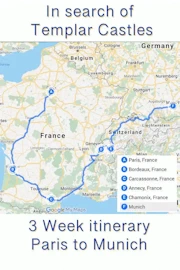
 Click above Image to view larger Google Map
